Zeeland geodata
Zeeland (North Brabant) is a populated place; located in Netherlands in Europe/Amsterdam (GMT+2) time zone. With population of 4,750 people, there are 510 cities with bigger population in this country. Compared to other cities in Netherlands, 69% of cities are located further ↑North; 50.8% of cities are located further ←West and 78.8% of cities have lower elevation than Zeeland. Note1


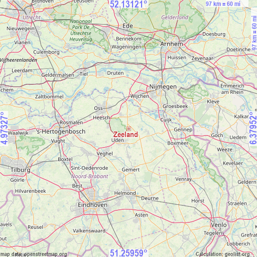
Zeeland GPS coordinates[2]
51° 41' 51" North, 5° 40' 35.004" East
| Map corner | latitude | longitude |
|---|---|---|
| Upper-left | 52.13121°, | 4.97327° |
| Center: | 51.6975°, | 5.67639° |
| Lower-right: | 51.25959°, | 6.37952° |
| Map W x H: | 96.9×96.9 km | = 60.2×60.2mi |
| max Lat: | 53.48025° ⇑69% North |
| Zeeland: | 51.6975° |
| min Lat: | ⇓31% South 50.76917° |
| min Long | Zeeland | max Long |
| 3.38611° | 5.67639° | 7.16528° |
| W 50.8%⇐ | ⇒49.2% E |
Elevation
Elevation of Zeeland is 20 m = 66 ft, and this is 5 m = 16 ft above average elevation for this country.
| Max E: |
203 m = 666 ft | 21.2% |
| Zeeland | 20 m 66 ft | |
| Avg. | 15 m = 49 ft | |
Min E: |
-6 m = -20 ft | 78.8% |
See also: Netherlands elevation on elevation.city.
Geographical zone
Zeeland is located in North temperate zone (between Tropic of Cancer and the Arctic Circle). Distance of this North polar circle is 1653 km =1027.1 mi to North.| Distance of | km | miles | from Zeeland |
|---|---|---|---|
| North Pole | 4258.8 | 2646.3 | to North |
| Arctic Circle | 1653 | 1027.1 | to North |
| Tropic Cancer | 3142.3 | 1952.5 | to South |
| Equator | 5748.2 | 3571.8 | to South |


Nearby cities:
15 places around Zeeland: (largest is in red/bold)
• Bitswijk
5.6 km =3.5 mi,  235°
235°
• Eikenheuvel
7.9 km =4.9 mi,  214°
214°
• Grave
8.1 km =5 mi,  32°
32°
• Herpen
8.6 km =5.3 mi,  343°
343°
• Hoeven
4 km =2.5 mi,  225°
225°
• Langenboom
3.8 km =2.4 mi,  78°
78°
• Melle
4.9 km =3 mi,  217°
217°
• Nistelrode
7.9 km =4.9 mi,  275°
275°
• Odiliapeel
6.4 km =4 mi,  161°
161°
• Raam
5 km =3.1 mi, 213°
• Reek
5.4 km =3.4 mi,  4°
4°
• Schaijk
6.2 km =3.9 mi,  330°
330°
• Uden
5.7 km =3.5 mi, 223°
• Volkel
6.3 km =3.9 mi,  194°
194°
• Wilbertoord
8.2 km =5.1 mi,  124°
124°
Sources, notices
• [Note1] Compared only with cities in Netherlands existing in our database
• [Src1] Map data: © OpenStreetMap contributors (CC-BY-SA)
• [Src2] Other city data from geonames.org with taken over terms of usage.
• [Src3] Geographical zone / Annual Mean Temperature by Robert A. Rohde @ Wikipedia
