Grashoek geodata
Grashoek (Limburg) is a populated place; located in Netherlands in Europe/Amsterdam (GMT+2) time zone. With population of 1,355 people, there are 1208 cities with bigger population in this country. Compared to other cities in Netherlands, 87.5% of cities are located further ↑North; 67.2% of cities are located further ←West and 90.9% of cities have lower elevation than Grashoek. Note1


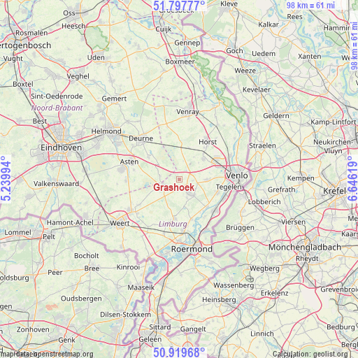
Grashoek GPS coordinates[2]
51° 21' 38.988" North, 5° 56' 35.016" East
| Map corner | latitude | longitude |
|---|---|---|
| Upper-left | 51.79777°, | 5.23994° |
| Center: | 51.36083°, | 5.94306° |
| Lower-right: | 50.91968°, | 6.64619° |
| Map W x H: | 97.6×97.6 km | = 60.6×60.6mi |
| max Lat: | 53.48025° ⇑87.5% North |
| Grashoek: | 51.36083° |
| min Lat: | ⇓12.5% South 50.76917° |
| min Long | Grashoek | max Long |
| 3.38611° | 5.94306° | 7.16528° |
| W 67.2%⇐ | ⇒32.8% E |
Elevation
Elevation of Grashoek is 35 m = 115 ft, and this is 20 m = 66 ft above average elevation for this country.
| Max E: |
203 m = 666 ft | 9.1% |
| Grashoek | 35 m 115 ft | |
| Avg. | 15 m = 49 ft | |
Min E: |
-6 m = -20 ft | 90.9% |
See also: Netherlands elevation on elevation.city.
Geographical zone
Grashoek is located in North temperate zone (between Tropic of Cancer and the Arctic Circle). Distance of this North polar circle is 1690.4 km =1050.4 mi to North.| Distance of | km | miles | from Grashoek |
|---|---|---|---|
| North Pole | 4296.3 | 2669.6 | to North |
| Arctic Circle | 1690.4 | 1050.4 | to North |
| Tropic Cancer | 3104.9 | 1929.3 | to South |
| Equator | 5710.8 | 3548.5 | to South |


Nearby cities:
15 places around Grashoek: (largest is in red/bold)
• America
8.8 km =5.5 mi,  16°
16°
• Beringe
2.7 km =1.7 mi,  171°
171°
• Bong
10.1 km =6.3 mi,  108°
108°
• Egchel
5.6 km =3.5 mi,  158°
158°
• Helden
6.1 km =3.8 mi,  139°
139°
• Helenaveen
3.7 km =2.3 mi,  330°
330°
• Kesseleik
10.7 km =6.6 mi,  148°
148°
• Koningslust
3.5 km =2.2 mi,  96°
96°
• Kronenberg
7.3 km =4.5 mi,  32°
32°
• Liessel
10.3 km =6.4 mi,  304°
304°
• Maasbree
7.3 km =4.5 mi,  92°
92°
• Meijel
4.5 km =2.8 mi,  245°
245°
• Neerkant
5.4 km =3.4 mi,  278°
278°
• Panningen
4.6 km =2.9 mi, 146°
• Sevenum
8.7 km =5.4 mi,  48°
48°
Sources, notices
• [Note1] Compared only with cities in Netherlands existing in our database
• [Src1] Map data: © OpenStreetMap contributors (CC-BY-SA)
• [Src2] Other city data from geonames.org with taken over terms of usage.
• [Src3] Geographical zone / Annual Mean Temperature by Robert A. Rohde @ Wikipedia
