Neerkant geodata
Neerkant (North Brabant) is a populated place; located in Netherlands in Europe/Amsterdam (GMT+2) time zone. With population of 1,325 people, there are 1224 cities with bigger population in this country. Compared to other cities in Netherlands, 87.4% of cities are located further ↑North; 61.8% of cities are located further ←West and 89.2% of cities have lower elevation than Neerkant. Note1


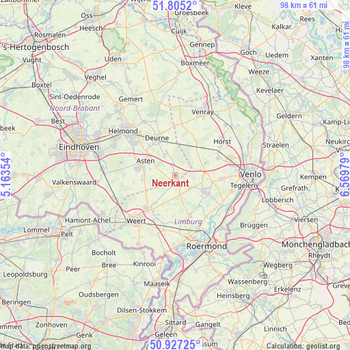
Neerkant GPS coordinates[2]
51° 22' 5.988" North, 5° 52' 0.012" East
| Map corner | latitude | longitude |
|---|---|---|
| Upper-left | 51.8052°, | 5.16354° |
| Center: | 51.36833°, | 5.86667° |
| Lower-right: | 50.92725°, | 6.56979° |
| Map W x H: | 97.6×97.6 km | = 60.6×60.6mi |
| max Lat: | 53.48025° ⇑87.4% North |
| Neerkant: | 51.36833° |
| min Lat: | ⇓12.6% South 50.76917° |
| min Long | Neerkant | max Long |
| 3.38611° | 5.86667° | 7.16528° |
| W 61.8%⇐ | ⇒38.2% E |
Elevation
Elevation of Neerkant is 32 m = 105 ft, and this is 17 m = 56 ft above average elevation for this country.
| Max E: |
203 m = 666 ft | 10.8% |
| Neerkant | 32 m 105 ft | |
| Avg. | 15 m = 49 ft | |
Min E: |
-6 m = -20 ft | 89.2% |
See also: Netherlands elevation on elevation.city.
Geographical zone
Neerkant is located in North temperate zone (between Tropic of Cancer and the Arctic Circle). Distance of this North polar circle is 1689.6 km =1049.9 mi to North.| Distance of | km | miles | from Neerkant |
|---|---|---|---|
| North Pole | 4295.4 | 2669 | to North |
| Arctic Circle | 1689.6 | 1049.9 | to North |
| Tropic Cancer | 3105.7 | 1929.8 | to South |
| Equator | 5711.6 | 3549 | to South |


Nearby cities:
15 places around Neerkant: (largest is in red/bold)
• Asten
9.1 km =5.7 mi,  295°
295°
• Beringe
6.7 km =4.2 mi,  121°
121°
• Egchel
9.5 km =5.9 mi,  129°
129°
• Grashoek
5.4 km =3.4 mi,  98°
98°
• Helenaveen
4.2 km =2.6 mi,  55°
55°
• Heusden
7.3 km =4.5 mi,  283°
283°
• Koningslust
8.9 km =5.5 mi, 97°
• Kronenberg
10.7 km =6.6 mi, 60°
• Liessel
5.9 km =3.7 mi,  327°
327°
• Meijel
3 km =1.9 mi,  154°
154°
• Ommel
10.3 km =6.4 mi,  307°
307°
• Ospel
9.7 km =6 mi,  215°
215°
• Panningen
9.1 km =5.7 mi, 120°
• Someren-Eind
9.3 km =5.8 mi,  262°
262°
• Zeilberg
10.2 km =6.3 mi,  340°
340°
Sources, notices
• [Note1] Compared only with cities in Netherlands existing in our database
• [Src1] Map data: © OpenStreetMap contributors (CC-BY-SA)
• [Src2] Other city data from geonames.org with taken over terms of usage.
• [Src3] Geographical zone / Annual Mean Temperature by Robert A. Rohde @ Wikipedia
