Liessel geodata
Liessel (North Brabant) is a populated place; located in Netherlands in Europe/Amsterdam (GMT+2) time zone. With population of 2,395 people, there are 864 cities with bigger population in this country. Compared to other cities in Netherlands, 85.8% of cities are located further ↑North; 59.1% of cities are located further ←West and 87.2% of cities have lower elevation than Liessel. Note1


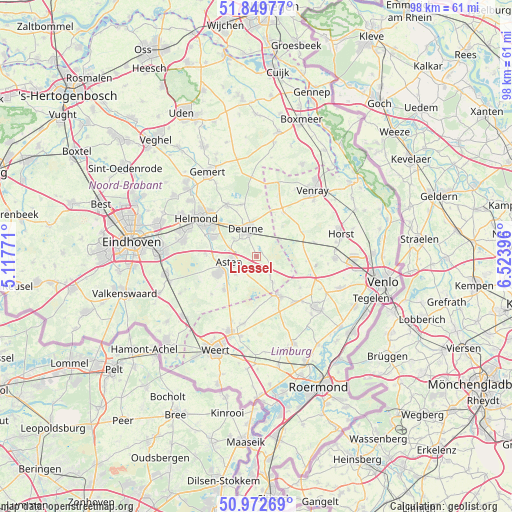
Liessel GPS coordinates[2]
51° 24' 47.988" North, 5° 49' 14.988" East
| Map corner | latitude | longitude |
|---|---|---|
| Upper-left | 51.84977°, | 5.11771° |
| Center: | 51.41333°, | 5.82083° |
| Lower-right: | 50.97269°, | 6.52396° |
| Map W x H: | 97.5×97.5 km | = 60.6×60.6mi |
| max Lat: | 53.48025° ⇑85.8% North |
| Liessel: | 51.41333° |
| min Lat: | ⇓14.2% South 50.76917° |
| min Long | Liessel | max Long |
| 3.38611° | 5.82083° | 7.16528° |
| W 59.1%⇐ | ⇒40.9% E |
Elevation
Elevation of Liessel is 29 m = 95 ft, and this is 14 m = 46 ft above average elevation for this country.
| Max E: |
203 m = 666 ft | 12.8% |
| Liessel | 29 m 95 ft | |
| Avg. | 15 m = 49 ft | |
Min E: |
-6 m = -20 ft | 87.2% |
See also: Netherlands elevation on elevation.city.
Geographical zone
Liessel is located in North temperate zone (between Tropic of Cancer and the Arctic Circle). Distance of this North polar circle is 1684.5 km =1046.7 mi to North.| Distance of | km | miles | from Liessel |
|---|---|---|---|
| North Pole | 4290.4 | 2665.9 | to North |
| Arctic Circle | 1684.5 | 1046.7 | to North |
| Tropic Cancer | 3110.7 | 1932.9 | to South |
| Equator | 5716.6 | 3552.1 | to South |


Nearby cities:
15 places around Liessel: (largest is in red/bold)
• Asten
5.1 km =3.2 mi,  258°
258°
• Grashoek
10.3 km =6.4 mi,  124°
124°
• Helenaveen
7.1 km =4.4 mi,  111°
111°
• Heusden
5.1 km =3.2 mi,  230°
230°
• Lierop
9.8 km =6.1 mi,  273°
273°
• Meijel
8.9 km =5.5 mi,  150°
150°
• Milheeze
10.2 km =6.3 mi,  343°
343°
• Neerkant
5.9 km =3.7 mi, 147°
• Ommel
5.2 km =3.2 mi,  283°
283°
• Someren
8.2 km =5.1 mi,  247°
247°
• Someren-Eind
8.7 km =5.4 mi,  224°
224°
• Vlierden
5.6 km =3.5 mi,  309°
309°
• Walsberg
6.9 km =4.3 mi,  349°
349°
• Ysselsteyn
10 km =6.2 mi,  31°
31°
• Zeilberg
4.6 km =2.9 mi,  358°
358°
Sources, notices
• [Note1] Compared only with cities in Netherlands existing in our database
• [Src1] Map data: © OpenStreetMap contributors (CC-BY-SA)
• [Src2] Other city data from geonames.org with taken over terms of usage.
• [Src3] Geographical zone / Annual Mean Temperature by Robert A. Rohde @ Wikipedia
