Giessendam geodata
Giessendam (South Holland) is a populated place; located in Netherlands in Europe/Amsterdam (GMT+2) time zone. With population of 5,235 people, there are 459 cities with bigger population in this country. Compared to other cities in Netherlands, 62.3% of cities are located further ↑North; 78.2% of cities are located further →East and 98.2% of cities have higher elevation than Giessendam. Note1


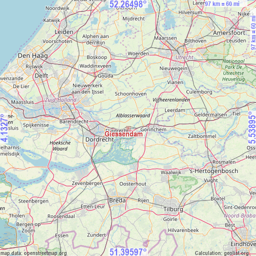
Giessendam GPS coordinates[2]
51° 49' 57.252" North, 4° 50' 8.988" East
| Map corner | latitude | longitude |
|---|---|---|
| Upper-left | 52.26498°, | 4.1327° |
| Center: | 51.83257°, | 4.83583° |
| Lower-right: | 51.39597°, | 5.53895° |
| Map W x H: | 96.6×96.6 km | = 60×60mi |
| max Lat: | 53.48025° ⇑62.3% North |
| Giessendam: | 51.83257° |
| min Lat: | ⇓37.7% South 50.76917° |
| min Long | Giessendam | max Long |
| 3.38611° | 4.83583° | 7.16528° |
| W 21.8%⇐ | ⇒78.2% E |
Elevation
Elevation of Giessendam is -2 m = -7 ft, and this is 17 m = 56 ft below average elevation for this country.
| Max E: |
203 m = 666 ft | 98.2% |
| Avg. | 15 m = 49 ft | |
| Giessendam | -2 m = -7 ft | |
Min E: |
-6 m = -20 ft | 1.8% |
See also: Netherlands elevation on elevation.city.
Geographical zone
Giessendam is located in North temperate zone (between Tropic of Cancer and the Arctic Circle). Distance of this North polar circle is 1637.9 km =1017.7 mi to North.| Distance of | km | miles | from Giessendam |
|---|---|---|---|
| North Pole | 4243.8 | 2637 | to North |
| Arctic Circle | 1637.9 | 1017.7 | to North |
| Tropic Cancer | 3157.3 | 1961.9 | to South |
| Equator | 5763.2 | 3581.1 | to South |


Nearby cities:
15 places around Giessendam: (largest is in red/bold)
• Bergstoep
10.6 km =6.6 mi,  340°
340°
• Bleskensgraaf
5.7 km =3.5 mi,  320°
320°
• Boven-Hardinxveld
3.3 km =2.1 mi,  107°
107°
• De Peulen
1.4 km =0.9 mi,  224°
224°
• Giessenburg
4.3 km =2.7 mi,  61°
61°
• Gorinchem
9.4 km =5.8 mi,  87°
87°
• Groot-Ammers
10.1 km =6.3 mi,  355°
355°
• Hoogblokland
10.7 km =6.6 mi, 63°
• Neder-Hardinxveld
1.4 km =0.9 mi, 107°
• Noordeloos
10.7 km =6.6 mi,  42°
42°
• Papendrecht
10.2 km =6.3 mi,  269°
269°
• Schelluinen
6.3 km =3.9 mi,  79°
79°
• Sliedrecht
4.3 km =2.7 mi,  252°
252°
• Werkendam
4.7 km =2.9 mi,  121°
121°
• Wijngaarden
5.2 km =3.2 mi,  285°
285°
Sources, notices
• [Note1] Compared only with cities in Netherlands existing in our database
• [Src1] Map data: © OpenStreetMap contributors (CC-BY-SA)
• [Src2] Other city data from geonames.org with taken over terms of usage.
• [Src3] Geographical zone / Annual Mean Temperature by Robert A. Rohde @ Wikipedia
