Neder-Hardinxveld geodata
Neder-Hardinxveld (South Holland) is a section of populated place; located in Netherlands in Europe/Amsterdam (GMT+2) time zone. With population of 5,335 people, there are 454 cities with bigger population in this country. Compared to other cities in Netherlands, 62.5% of cities are located further ↑North; 77.8% of cities are located further →East and 91.3% of cities have higher elevation than Neder-Hardinxveld. Note1


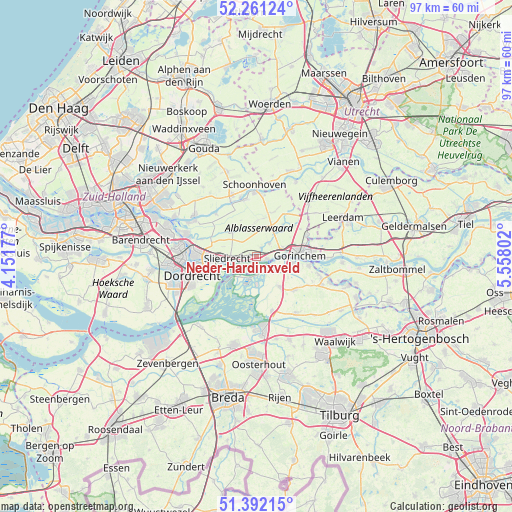
Neder-Hardinxveld GPS coordinates[2]
51° 49' 43.644" North, 4° 51' 17.604" East
| Map corner | latitude | longitude |
|---|---|---|
| Upper-left | 52.26124°, | 4.15177° |
| Center: | 51.82879°, | 4.85489° |
| Lower-right: | 51.39215°, | 5.55802° |
| Map W x H: | 96.6×96.6 km | = 60×60mi |
| max Lat: | 53.48025° ⇑62.5% North |
| Neder-Hardinxveld: | 51.82879° |
| min Lat: | ⇓37.5% South 50.76917° |
| min Long | Neder-Hardinxve | max Long |
| 3.38611° | 4.85489° | 7.16528° |
| W 22.2%⇐ | ⇒77.8% E |
Elevation
Elevation of Neder-Hardinxveld is 0 m = 0 ft, and this is 15 m = 49 ft below average elevation for this country.
| Max E: |
203 m = 666 ft | 91.3% |
| Avg. | 15 m = 49 ft | |
| Neder-Hardinxveld | 0 m = 0 ft | |
Min E: |
-6 m = -20 ft | 8.7% |
See also: Netherlands elevation on elevation.city.
Geographical zone
Neder-Hardinxveld is located in North temperate zone (between Tropic of Cancer and the Arctic Circle). Distance of this North polar circle is 1638.4 km =1018.1 mi to North.| Distance of | km | miles | from Neder-Hardinxveld |
|---|---|---|---|
| North Pole | 4244.2 | 2637.2 | to North |
| Arctic Circle | 1638.4 | 1018.1 | to North |
| Tropic Cancer | 3156.9 | 1961.6 | to South |
| Equator | 5762.8 | 3580.8 | to South |


Nearby cities:
15 places around Neder-Hardinxveld: (largest is in red/bold)
• Almkerk
9.7 km =6 mi,  131°
131°
• Arkel
10.4 km =6.5 mi,  67°
67°
• Bleskensgraaf
6.9 km =4.3 mi,  314°
314°
• Boven-Hardinxveld
2 km =1.2 mi,  108°
108°
• De Peulen
2.4 km =1.5 mi,  255°
255°
• Giessenburg
3.5 km =2.2 mi,  44°
44°
• Giessendam
1.4 km =0.9 mi,  287°
287°
• Gorinchem
8.1 km =5 mi,  83°
83°
• Hoogblokland
9.8 km =6.1 mi,  58°
58°
• Noordeloos
10.2 km =6.3 mi, 35°
• Schelluinen
5.2 km =3.2 mi, 71°
• Sliedrecht
5.5 km =3.4 mi, 260°
• Werkendam
3.4 km =2.1 mi, 127°
• Wijngaarden
6.6 km =4.1 mi, 285°
• Woudrichem
10.2 km =6.3 mi,  98°
98°
Sources, notices
• [Note1] Compared only with cities in Netherlands existing in our database
• [Src1] Map data: © OpenStreetMap contributors (CC-BY-SA)
• [Src2] Other city data from geonames.org with taken over terms of usage.
• [Src3] Geographical zone / Annual Mean Temperature by Robert A. Rohde @ Wikipedia
