Gieten geodata
Gieten (Drenthe) is a populated place; located in Netherlands in Europe/Amsterdam (GMT+2) time zone. With population of 4,885 people, there are 498 cities with bigger population in this country. Compared to other cities in Netherlands, 85.7% of cities are located further ↓South; 94.8% of cities are located further ←West and 78.8% of cities have lower elevation than Gieten. Note1


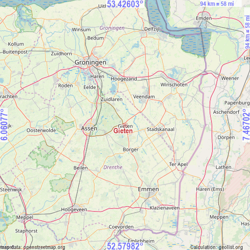
Gieten GPS coordinates[2]
53° 0' 18" North, 6° 45' 50.004" East
| Map corner | latitude | longitude |
|---|---|---|
| Upper-left | 53.42603°, | 6.06077° |
| Center: | 53.005°, | 6.76389° |
| Lower-right: | 52.57982°, | 7.46702° |
| Map W x H: | 94.1×94.1 km | = 58.5×58.5mi |
| max Lat: | 53.48025° ⇑14.3% North |
| Gieten: | 53.005° |
| min Lat: | ⇓85.7% South 50.76917° |
| min Long | Gieten | max Long |
| 3.38611° | 6.76389° | 7.16528° |
| W 94.8%⇐ | ⇒5.2% E |
Elevation
Elevation of Gieten is 20 m = 66 ft, and this is 5 m = 16 ft above average elevation for this country.
| Max E: |
203 m = 666 ft | 21.2% |
| Gieten | 20 m 66 ft | |
| Avg. | 15 m = 49 ft | |
Min E: |
-6 m = -20 ft | 78.8% |
See also: Netherlands elevation on elevation.city.
Geographical zone
Gieten is located in North temperate zone (between Tropic of Cancer and the Arctic Circle). Distance of this North polar circle is 1507.6 km =936.8 mi to North.| Distance of | km | miles | from Gieten |
|---|---|---|---|
| North Pole | 4113.5 | 2556 | to North |
| Arctic Circle | 1507.6 | 936.8 | to North |
| Tropic Cancer | 3287.7 | 2042.9 | to South |
| Equator | 5893.6 | 3662.1 | to South |


Nearby cities:
15 places around Gieten: (largest is in red/bold)
• Annen
6.6 km =4.1 mi,  333°
333°
• Borger
9.3 km =5.8 mi,  167°
167°
• Buinen
9.6 km =6 mi,  149°
149°
• Drouwenermond
9.9 km =6.2 mi,  107°
107°
• Eext
2.4 km =1.5 mi,  305°
305°
• Gasselte
4.2 km =2.6 mi, 151°
• Gasselternijveen
6.2 km =3.9 mi, 107°
• Gasselternijveenschemond
9.1 km =5.7 mi,  97°
97°
• Gieterveen
5.5 km =3.4 mi,  63°
63°
• Grolloo
9.9 km =6.2 mi,  218°
218°
• Rolde
8.1 km =5 mi,  253°
253°
• Schipborg
10 km =6.2 mi,  321°
321°
• Westlaren
11.1 km =6.9 mi, 323°
• Wildervank
10.7 km =6.6 mi,  38°
38°
• Zuidlaren
11.3 km =7 mi, 331°
Sources, notices
• [Note1] Compared only with cities in Netherlands existing in our database
• [Src1] Map data: © OpenStreetMap contributors (CC-BY-SA)
• [Src2] Other city data from geonames.org with taken over terms of usage.
• [Src3] Geographical zone / Annual Mean Temperature by Robert A. Rohde @ Wikipedia
