Dwingeloo geodata
Dwingeloo (Drenthe) is a populated place; located in Netherlands in Europe/Amsterdam (GMT+2) time zone. With population of 2,430 people, there are 855 cities with bigger population in this country. Compared to other cities in Netherlands, 80.6% of cities are located further ↓South; 86.7% of cities are located further ←West and 62% of cities have lower elevation than Dwingeloo. Note1


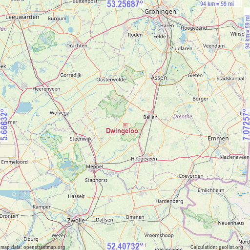
Dwingeloo GPS coordinates[2]
52° 50' 3.012" North, 6° 22' 9.984" East
| Map corner | latitude | longitude |
|---|---|---|
| Upper-left | 53.25687°, | 5.66632° |
| Center: | 52.83417°, | 6.36944° |
| Lower-right: | 52.40732°, | 7.07257° |
| Map W x H: | 94.5×94.5 km | = 58.7×58.7mi |
| max Lat: | 53.48025° ⇑19.4% North |
| Dwingeloo: | 52.83417° |
| min Lat: | ⇓80.6% South 50.76917° |
| min Long | Dwingeloo | max Long |
| 3.38611° | 6.36944° | 7.16528° |
| W 86.7%⇐ | ⇒13.3% E |
Elevation
Elevation of Dwingeloo is 11 m = 36 ft, and this is 4 m = 13 ft below average elevation for this country.
| Max E: |
203 m = 666 ft | 38% |
| Avg. | 15 m = 49 ft | |
| Dwingeloo | 11 m = 36 ft | |
Min E: |
-6 m = -20 ft | 62% |
See also: Netherlands elevation on elevation.city.
Geographical zone
Dwingeloo is located in North temperate zone (between Tropic of Cancer and the Arctic Circle). Distance of this North polar circle is 1526.6 km =948.6 mi to North.| Distance of | km | miles | from Dwingeloo |
|---|---|---|---|
| North Pole | 4132.5 | 2567.8 | to North |
| Arctic Circle | 1526.6 | 948.6 | to North |
| Tropic Cancer | 3268.7 | 2031.1 | to South |
| Equator | 5874.6 | 3650.3 | to South |


Nearby cities:
15 places around Dwingeloo: (largest is in red/bold)
• Appelscha
13.5 km =8.4 mi,  354°
354°
• Beilen
10.2 km =6.3 mi,  71°
71°
• Boijl
14.1 km =8.8 mi,  306°
306°
• Darp
12.9 km =8 mi,  239°
239°
• Diever
4.1 km =2.5 mi,  302°
302°
• Havelte
11.3 km =7 mi,  230°
230°
• Hijken
10.9 km =6.8 mi,  51°
51°
• Hoogeveen
14.3 km =8.9 mi,  149°
149°
• Hooghalen
14.9 km =9.3 mi, 49°
• Ruinen
8 km =5 mi,  187°
187°
• Ruinerwold
14.8 km =9.2 mi,  213°
213°
• Uffelte
7.7 km =4.8 mi, 230°
• Vledder
11.1 km =6.9 mi,  282°
282°
• Wijster
10.2 km =6.3 mi,  101°
101°
• Wilhelminaoord
14 km =8.7 mi, 279°
Sources, notices
• [Note1] Compared only with cities in Netherlands existing in our database
• [Src1] Map data: © OpenStreetMap contributors (CC-BY-SA)
• [Src2] Other city data from geonames.org with taken over terms of usage.
• [Src3] Geographical zone / Annual Mean Temperature by Robert A. Rohde @ Wikipedia
