Hooghalen geodata
Hooghalen (Drenthe) is a populated place; located in Netherlands in Europe/Amsterdam (GMT+2) time zone. With population of 810 people, there are 1524 cities with bigger population in this country. Compared to other cities in Netherlands, 83.1% of cities are located further ↓South; 89.7% of cities are located further ←West and 74.9% of cities have lower elevation than Hooghalen. Note1


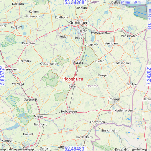
Hooghalen GPS coordinates[2]
52° 55' 14.988" North, 6° 32' 20.004" East
| Map corner | latitude | longitude |
|---|---|---|
| Upper-left | 53.34268°, | 5.83577° |
| Center: | 52.92083°, | 6.53889° |
| Lower-right: | 52.49483°, | 7.24202° |
| Map W x H: | 94.3×94.3 km | = 58.6×58.6mi |
| max Lat: | 53.48025° ⇑16.9% North |
| Hooghalen: | 52.92083° |
| min Lat: | ⇓83.1% South 50.76917° |
| min Long | Hooghalen | max Long |
| 3.38611° | 6.53889° | 7.16528° |
| W 89.7%⇐ | ⇒10.3% E |
Elevation
Elevation of Hooghalen is 18 m = 59 ft, and this is 3 m = 10 ft above average elevation for this country.
| Max E: |
203 m = 666 ft | 25.1% |
| Hooghalen | 18 m 59 ft | |
| Avg. | 15 m = 49 ft | |
Min E: |
-6 m = -20 ft | 74.9% |
See also: Netherlands elevation on elevation.city.
Geographical zone
Hooghalen is located in North temperate zone (between Tropic of Cancer and the Arctic Circle). Distance of this North polar circle is 1516.9 km =942.6 mi to North.| Distance of | km | miles | from Hooghalen |
|---|---|---|---|
| North Pole | 4122.8 | 2561.8 | to North |
| Arctic Circle | 1516.9 | 942.6 | to North |
| Tropic Cancer | 3278.3 | 2037 | to South |
| Equator | 5884.2 | 3656.3 | to South |


Nearby cities:
15 places around Hooghalen: (largest is in red/bold)
• Appelscha
13.2 km =8.2 mi,  286°
286°
• Assen
8.6 km =5.3 mi,  10°
10°
• Beilen
6.6 km =4.1 mi,  194°
194°
• Diever
16.6 km =10.3 mi,  243°
243°
• Dwingeloo
14.9 km =9.3 mi,  229°
229°
• Grolloo
9.1 km =5.7 mi,  80°
80°
• Hijken
4 km =2.5 mi,  224°
224°
• Marsdijk
11.2 km =7 mi,  16°
16°
• Peelo
10.8 km =6.7 mi, 8°
• Rolde
10.2 km =6.3 mi,  46°
46°
• Schoonoord
16.8 km =10.4 mi,  119°
119°
• Veenhuizen
15.6 km =9.7 mi,  322°
322°
• Westerbork
9.2 km =5.7 mi,  149°
149°
• Wijster
11.7 km =7.3 mi, 186°
• Zeyen
14.1 km =8.8 mi,  1°
1°
Sources, notices
• [Note1] Compared only with cities in Netherlands existing in our database
• [Src1] Map data: © OpenStreetMap contributors (CC-BY-SA)
• [Src2] Other city data from geonames.org with taken over terms of usage.
• [Src3] Geographical zone / Annual Mean Temperature by Robert A. Rohde @ Wikipedia
