Diever geodata
Diever (Drenthe) is a populated place; located in Netherlands in Europe/Amsterdam (GMT+2) time zone. With population of 2,175 people, there are 918 cities with bigger population in this country. Compared to other cities in Netherlands, 81.4% of cities are located further ↓South; 86% of cities are located further ←West and 62% of cities have lower elevation than Diever. Note1


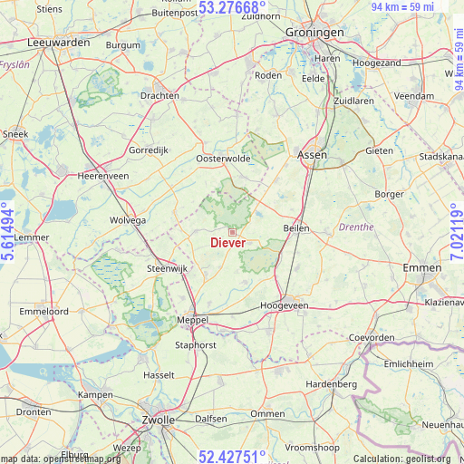
Diever GPS coordinates[2]
52° 51' 15.012" North, 6° 19' 5.016" East
| Map corner | latitude | longitude |
|---|---|---|
| Upper-left | 53.27668°, | 5.61494° |
| Center: | 52.85417°, | 6.31806° |
| Lower-right: | 52.42751°, | 7.02119° |
| Map W x H: | 94.4×94.4 km | = 58.7×58.7mi |
| max Lat: | 53.48025° ⇑18.6% North |
| Diever: | 52.85417° |
| min Lat: | ⇓81.4% South 50.76917° |
| min Long | Diever | max Long |
| 3.38611° | 6.31806° | 7.16528° |
| W 86%⇐ | ⇒14% E |
Elevation
Elevation of Diever is 11 m = 36 ft, and this is 4 m = 13 ft below average elevation for this country.
| Max E: |
203 m = 666 ft | 38% |
| Avg. | 15 m = 49 ft | |
| Diever | 11 m = 36 ft | |
Min E: |
-6 m = -20 ft | 62% |
See also: Netherlands elevation on elevation.city.
Geographical zone
Diever is located in North temperate zone (between Tropic of Cancer and the Arctic Circle). Distance of this North polar circle is 1524.3 km =947.2 mi to North.| Distance of | km | miles | from Diever |
|---|---|---|---|
| North Pole | 4130.2 | 2566.4 | to North |
| Arctic Circle | 1524.3 | 947.2 | to North |
| Tropic Cancer | 3270.9 | 2032.4 | to South |
| Equator | 5876.8 | 3651.7 | to South |


Nearby cities:
15 places around Diever: (largest is in red/bold)
• Appelscha
11.4 km =7.1 mi,  10°
10°
• Beilen
13.2 km =8.2 mi,  85°
85°
• Boijl
10 km =6.2 mi,  307°
307°
• Darp
11.7 km =7.3 mi,  221°
221°
• Dwingeloo
4.1 km =2.5 mi,  122°
122°
• Havelte
10.8 km =6.7 mi,  209°
209°
• Hijken
12.9 km =8 mi,  69°
69°
• Noordwolde
12.5 km =7.8 mi,  288°
288°
• Oostermeenthe
14.3 km =8.9 mi,  241°
241°
• Oosterstreek
11.6 km =7.2 mi, 294°
• Ruinen
10.5 km =6.5 mi,  166°
166°
• Uffelte
7.6 km =4.7 mi,  199°
199°
• Vledder
7.4 km =4.6 mi,  271°
271°
• Wijster
14.1 km =8.8 mi,  107°
107°
• Wilhelminaoord
10.4 km =6.5 mi, 271°
Sources, notices
• [Note1] Compared only with cities in Netherlands existing in our database
• [Src1] Map data: © OpenStreetMap contributors (CC-BY-SA)
• [Src2] Other city data from geonames.org with taken over terms of usage.
• [Src3] Geographical zone / Annual Mean Temperature by Robert A. Rohde @ Wikipedia
