Hijken geodata
Hijken (Drenthe) is a populated place; located in Netherlands in Europe/Amsterdam (GMT+2) time zone. With population of 640 people, there are 1678 cities with bigger population in this country. Compared to other cities in Netherlands, 82.6% of cities are located further ↓South; 88.6% of cities are located further ←West and 70.6% of cities have lower elevation than Hijken. Note1


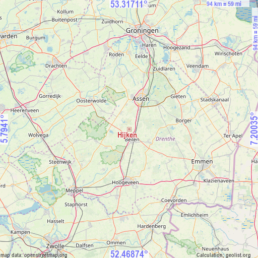
Hijken GPS coordinates[2]
52° 53' 42" North, 6° 29' 49.992" East
| Map corner | latitude | longitude |
|---|---|---|
| Upper-left | 53.31711°, | 5.7941° |
| Center: | 52.895°, | 6.49722° |
| Lower-right: | 52.46874°, | 7.20035° |
| Map W x H: | 94.3×94.3 km | = 58.6×58.6mi |
| max Lat: | 53.48025° ⇑17.4% North |
| Hijken: | 52.895° |
| min Lat: | ⇓82.6% South 50.76917° |
| min Long | Hijken | max Long |
| 3.38611° | 6.49722° | 7.16528° |
| W 88.6%⇐ | ⇒11.4% E |
Elevation
Elevation of Hijken is 15 m = 49 ft, and this is 0 m = 0 ft above average elevation for this country.
| Max E: |
203 m = 666 ft | 29.4% |
| Hijken | 15 m 49 ft | |
| Avg. | 15 m = 49 ft | |
Min E: |
-6 m = -20 ft | 70.6% |
See also: Netherlands elevation on elevation.city.
Geographical zone
Hijken is located in North temperate zone (between Tropic of Cancer and the Arctic Circle). Distance of this North polar circle is 1519.8 km =944.4 mi to North.| Distance of | km | miles | from Hijken |
|---|---|---|---|
| North Pole | 4125.7 | 2563.6 | to North |
| Arctic Circle | 1519.8 | 944.4 | to North |
| Tropic Cancer | 3275.5 | 2035.3 | to South |
| Equator | 5881.4 | 3654.5 | to South |


Nearby cities:
15 places around Hijken: (largest is in red/bold)
• Appelscha
11.9 km =7.4 mi,  304°
304°
• Assen
12.1 km =7.5 mi,  21°
21°
• Beilen
3.7 km =2.3 mi,  162°
162°
• Diever
12.9 km =8 mi,  249°
249°
• Dwingeloo
10.9 km =6.8 mi,  231°
231°
• Grolloo
12.5 km =7.8 mi,  69°
69°
• Hooghalen
4 km =2.5 mi,  44°
44°
• Marsdijk
14.9 km =9.3 mi, 23°
• Nieuw-Balinge
16.1 km =10 mi,  152°
152°
• Peelo
14.3 km =8.9 mi, 17°
• Rolde
14.2 km =8.8 mi,  45°
45°
• Veenhuizen
16.6 km =10.3 mi,  335°
335°
• Westerbork
9 km =5.6 mi,  123°
123°
• Wijster
8.8 km =5.5 mi,  170°
170°
• Zeyen
17.3 km =10.7 mi,  10°
10°
Sources, notices
• [Note1] Compared only with cities in Netherlands existing in our database
• [Src1] Map data: © OpenStreetMap contributors (CC-BY-SA)
• [Src2] Other city data from geonames.org with taken over terms of usage.
• [Src3] Geographical zone / Annual Mean Temperature by Robert A. Rohde @ Wikipedia
