Haaren geodata
Haaren (North Brabant) is a populated place; located in Netherlands in Europe/Amsterdam (GMT+2) time zone. With population of 3,835 people, there are 616 cities with bigger population in this country. Compared to other cities in Netherlands, 73.8% of cities are located further ↑North; 65.9% of cities are located further →East and 57.3% of cities have lower elevation than Haaren. Note1


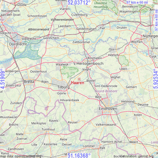
Haaren GPS coordinates[2]
51° 36' 9" North, 5° 13' 19.992" East
| Map corner | latitude | longitude |
|---|---|---|
| Upper-left | 52.03712°, | 4.51909° |
| Center: | 51.6025°, | 5.22222° |
| Lower-right: | 51.16368°, | 5.92534° |
| Map W x H: | 97.1×97.1 km | = 60.3×60.3mi |
| max Lat: | 53.48025° ⇑73.8% North |
| Haaren: | 51.6025° |
| min Lat: | ⇓26.2% South 50.76917° |
| min Long | Haaren | max Long |
| 3.38611° | 5.22222° | 7.16528° |
| W 34.1%⇐ | ⇒65.9% E |
Elevation
Elevation of Haaren is 9 m = 30 ft, and this is 6 m = 20 ft below average elevation for this country.
| Max E: |
203 m = 666 ft | 42.7% |
| Avg. | 15 m = 49 ft | |
| Haaren | 9 m = 30 ft | |
Min E: |
-6 m = -20 ft | 57.3% |
See also: Netherlands elevation on elevation.city.
Geographical zone
Haaren is located in North temperate zone (between Tropic of Cancer and the Arctic Circle). Distance of this North polar circle is 1663.5 km =1033.7 mi to North.| Distance of | km | miles | from Haaren |
|---|---|---|---|
| North Pole | 4269.4 | 2652.9 | to North |
| Arctic Circle | 1663.5 | 1033.7 | to North |
| Tropic Cancer | 3131.7 | 1945.9 | to South |
| Equator | 5737.7 | 3565.2 | to South |


Nearby cities:
15 places around Haaren: (largest is in red/bold)
• Biezenmortel
3.9 km =2.4 mi,  308°
308°
• Boxtel
7.5 km =4.7 mi,  99°
99°
• Cromvoirt
6.5 km =4 mi,  5°
5°
• Deuteren
9.8 km =6.1 mi,  18°
18°
• Enschot
6.3 km =3.9 mi,  245°
245°
• Esch
4.8 km =3 mi,  78°
78°
• Gemonde
9.5 km =5.9 mi, 79°
• Helvoirt
3.3 km =2.1 mi, 10°
• Lennisheuvel
7.2 km =4.5 mi,  117°
117°
• Loven
9.6 km =6 mi,  244°
244°
• Oisterwijk
3.5 km =2.2 mi,  221°
221°
• Quirijnstok
8.8 km =5.5 mi,  256°
256°
• Theereheide
8.9 km =5.5 mi,  63°
63°
• Udenhout
5.5 km =3.4 mi,  277°
277°
• Vught
7.2 km =4.5 mi,  38°
38°
Sources, notices
• [Note1] Compared only with cities in Netherlands existing in our database
• [Src1] Map data: © OpenStreetMap contributors (CC-BY-SA)
• [Src2] Other city data from geonames.org with taken over terms of usage.
• [Src3] Geographical zone / Annual Mean Temperature by Robert A. Rohde @ Wikipedia
