Casteren geodata
Casteren (North Brabant) is a populated place; located in Netherlands in Europe/Amsterdam (GMT+2) time zone. With population of 990 people, there are 1411 cities with bigger population in this country. Compared to other cities in Netherlands, 86.4% of cities are located further ↑North; 65.4% of cities are located further →East and 84.6% of cities have lower elevation than Casteren. Note1


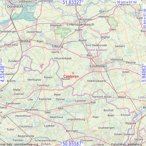
Casteren GPS coordinates[2]
51° 23' 48.012" North, 5° 14' 15" East
| Map corner | latitude | longitude |
|---|---|---|
| Upper-left | 51.83327°, | 4.53438° |
| Center: | 51.39667°, | 5.2375° |
| Lower-right: | 50.95587°, | 5.94063° |
| Map W x H: | 97.6×97.6 km | = 60.6×60.6mi |
| max Lat: | 53.48025° ⇑86.4% North |
| Casteren: | 51.39667° |
| min Lat: | ⇓13.6% South 50.76917° |
| min Long | Casteren | max Long |
| 3.38611° | 5.2375° | 7.16528° |
| W 34.6%⇐ | ⇒65.4% E |
Elevation
Elevation of Casteren is 26 m = 85 ft, and this is 11 m = 36 ft above average elevation for this country.
| Max E: |
203 m = 666 ft | 15.4% |
| Casteren | 26 m 85 ft | |
| Avg. | 15 m = 49 ft | |
Min E: |
-6 m = -20 ft | 84.6% |
See also: Netherlands elevation on elevation.city.
Geographical zone
Casteren is located in North temperate zone (between Tropic of Cancer and the Arctic Circle). Distance of this North polar circle is 1686.4 km =1047.9 mi to North.| Distance of | km | miles | from Casteren |
|---|---|---|---|
| North Pole | 4292.3 | 2667.1 | to North |
| Arctic Circle | 1686.4 | 1047.9 | to North |
| Tropic Cancer | 3108.9 | 1931.8 | to South |
| Equator | 5714.8 | 3551 | to South |


Nearby cities:
15 places around Casteren: (largest is in red/bold)
• Bladel
3.4 km =2.1 mi,  200°
200°
• Diessen
9.8 km =6.1 mi,  333°
333°
• Duizel
5.2 km =3.2 mi,  127°
127°
• Eersel
7.1 km =4.4 mi, 127°
• Hapert
3.4 km =2.1 mi,  156°
156°
• Hooge Mierde
7.6 km =4.7 mi,  262°
262°
• Hoogeloon
2.1 km =1.3 mi,  87°
87°
• Hulsel
4.2 km =2.6 mi, 257°
• Lage Mierde
6.3 km =3.9 mi,  279°
279°
• Middelbeers
7.8 km =4.8 mi,  6°
6°
• Netersel
2.2 km =1.4 mi,  290°
290°
• Oerle
9.7 km =6 mi,  72°
72°
• Oostelbeers
8.6 km =5.3 mi, 14°
• Reusel
6.3 km =3.9 mi,  232°
232°
• Steensel
8.3 km =5.2 mi,  105°
105°
Sources, notices
• [Note1] Compared only with cities in Netherlands existing in our database
• [Src1] Map data: © OpenStreetMap contributors (CC-BY-SA)
• [Src2] Other city data from geonames.org with taken over terms of usage.
• [Src3] Geographical zone / Annual Mean Temperature by Robert A. Rohde @ Wikipedia
