Bantega geodata
Bantega (Friesland) is a populated place; located in Netherlands in Europe/Amsterdam (GMT+2) time zone. With population of 635 people, there are 1680 cities with bigger population in this country. Compared to other cities in Netherlands, 80.9% of cities are located further ↓South; 57.5% of cities are located further ←West and 96.1% of cities have higher elevation than Bantega. Note1


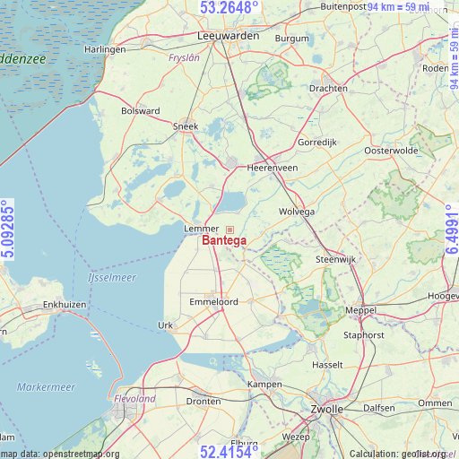
Bantega GPS coordinates[2]
52° 50' 31.848" North, 5° 47' 45.492" East
| Map corner | latitude | longitude |
|---|---|---|
| Upper-left | 53.2648°, | 5.09285° |
| Center: | 52.84218°, | 5.79597° |
| Lower-right: | 52.4154°, | 6.4991° |
| Map W x H: | 94.4×94.4 km | = 58.7×58.7mi |
| max Lat: | 53.48025° ⇑19.1% North |
| Bantega: | 52.84218° |
| min Lat: | ⇓80.9% South 50.76917° |
| min Long | Bantega | max Long |
| 3.38611° | 5.79597° | 7.16528° |
| W 57.5%⇐ | ⇒42.5% E |
Elevation
Elevation of Bantega is -1 m = -3 ft, and this is 16 m = 52 ft below average elevation for this country.
| Max E: |
203 m = 666 ft | 96.1% |
| Avg. | 15 m = 49 ft | |
| Bantega | -1 m = -3 ft | |
Min E: |
-6 m = -20 ft | 3.9% |
See also: Netherlands elevation on elevation.city.
Geographical zone
Bantega is located in North temperate zone (between Tropic of Cancer and the Arctic Circle). Distance of this North polar circle is 1525.7 km =948 mi to North.| Distance of | km | miles | from Bantega |
|---|---|---|---|
| North Pole | 4131.6 | 2567.3 | to North |
| Arctic Circle | 1525.7 | 948 | to North |
| Tropic Cancer | 3269.6 | 2031.6 | to South |
| Equator | 5875.5 | 3650.9 | to South |


Nearby cities:
15 places around Bantega: (largest is in red/bold)
• Echtenerbrug
3.7 km =2.3 mi,  27°
27°
• Haskerhorne
12.6 km =7.8 mi,  10°
10°
• Joure
13.7 km =8.5 mi,  1°
1°
• Kuinre
6.8 km =4.2 mi,  153°
153°
• Langweer
13.8 km =8.6 mi,  338°
338°
• Lemmer
5.8 km =3.6 mi,  274°
274°
• Oldemarkt
12.3 km =7.6 mi,  101°
101°
• Oudehaske
13.7 km =8.5 mi,  21°
21°
• Rotsterhaule
9.4 km =5.8 mi, 23°
• Rottum
12.4 km =7.7 mi, 32°
• Scharsterbrug
11.4 km =7.1 mi,  354°
354°
• Sint Nicolaasga
9.7 km =6 mi, 338°
• Sintjohannesga
10.7 km =6.6 mi, 22°
• Sloten
11.7 km =7.3 mi,  300°
300°
• Wijckel
12.7 km =7.9 mi,  293°
293°
Sources, notices
• [Note1] Compared only with cities in Netherlands existing in our database
• [Src1] Map data: © OpenStreetMap contributors (CC-BY-SA)
• [Src2] Other city data from geonames.org with taken over terms of usage.
• [Src3] Geographical zone / Annual Mean Temperature by Robert A. Rohde @ Wikipedia
