Zuidhorn geodata
Zuidhorn (Groningen) is a populated place; located in Netherlands in Europe/Amsterdam (GMT+2) time zone. With population of 7,075 people, there are 361 cities with bigger population in this country. Compared to other cities in Netherlands, 95.6% of cities are located further ↓South; 87.5% of cities are located further ←West and 58.8% of cities have higher elevation than Zuidhorn. Note1


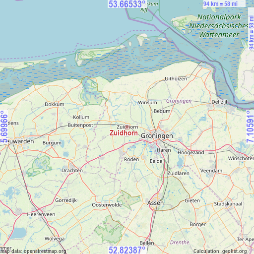
Zuidhorn GPS coordinates[2]
53° 14' 48.012" North, 6° 24' 10.008" East
| Map corner | latitude | longitude |
|---|---|---|
| Upper-left | 53.66533°, | 5.69966° |
| Center: | 53.24667°, | 6.40278° |
| Lower-right: | 52.82387°, | 7.10591° |
| Map W x H: | 93.6×93.6 km | = 58.2×58.2mi |
| max Lat: | 53.48025° ⇑4.4% North |
| Zuidhorn: | 53.24667° |
| min Lat: | ⇓95.6% South 50.76917° |
| min Long | Zuidhorn | max Long |
| 3.38611° | 6.40278° | 7.16528° |
| W 87.5%⇐ | ⇒12.5% E |
Elevation
Elevation of Zuidhorn is 4 m = 13 ft, and this is 11 m = 36 ft below average elevation for this country.
| Max E: |
203 m = 666 ft | 58.8% |
| Avg. | 15 m = 49 ft | |
| Zuidhorn | 4 m = 13 ft | |
Min E: |
-6 m = -20 ft | 41.2% |
See also: Netherlands elevation on elevation.city.
Geographical zone
Zuidhorn is located in North temperate zone (between Tropic of Cancer and the Arctic Circle). Distance of this North polar circle is 1480.7 km =920.1 mi to North.| Distance of | km | miles | from Zuidhorn |
|---|---|---|---|
| North Pole | 4086.6 | 2539.3 | to North |
| Arctic Circle | 1480.7 | 920.1 | to North |
| Tropic Cancer | 3314.6 | 2059.6 | to South |
| Equator | 5920.5 | 3678.8 | to South |


Nearby cities:
15 places around Zuidhorn: (largest is in red/bold)
• Adorp
9.2 km =5.7 mi,  70°
70°
• Aduard
3.9 km =2.4 mi, 73°
• Ezinge
7.5 km =4.7 mi,  20°
20°
• Grijpskerk
6.5 km =4 mi,  285°
285°
• Grootegast
9.4 km =5.8 mi,  246°
246°
• Kommerzijl
6.8 km =4.2 mi,  310°
310°
• Leek
9.5 km =5.9 mi,  190°
190°
• Lutjegast
9.7 km =6 mi,  261°
261°
• Niekerk
4.1 km =2.5 mi,  234°
234°
• Nietap
9.7 km =6 mi,  181°
181°
• Noordhorn
1.7 km =1.1 mi,  344°
344°
• Oldehove
6.3 km =3.9 mi,  355°
355°
• Oldekerk
5.2 km =3.2 mi, 233°
• Reitdiep
7.8 km =4.8 mi,  93°
93°
• Sauwerd
10.2 km =6.3 mi,  59°
59°
Sources, notices
• [Note1] Compared only with cities in Netherlands existing in our database
• [Src1] Map data: © OpenStreetMap contributors (CC-BY-SA)
• [Src2] Other city data from geonames.org with taken over terms of usage.
• [Src3] Geographical zone / Annual Mean Temperature by Robert A. Rohde @ Wikipedia
