Noordhorn geodata
Noordhorn (Groningen) is a populated place; located in Netherlands in Europe/Amsterdam (GMT+2) time zone. With population of 1,375 people, there are 1194 cities with bigger population in this country. Compared to other cities in Netherlands, 96.2% of cities are located further ↓South; 87.2% of cities are located further ←West and 50.6% of cities have higher elevation than Noordhorn. Note1


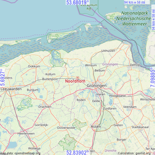
Noordhorn GPS coordinates[2]
53° 15' 42.012" North, 6° 23' 44.988" East
| Map corner | latitude | longitude |
|---|---|---|
| Upper-left | 53.68019°, | 5.6927° |
| Center: | 53.26167°, | 6.39583° |
| Lower-right: | 52.83902°, | 7.09895° |
| Map W x H: | 93.5×93.5 km | = 58.1×58.1mi |
| max Lat: | 53.48025° ⇑3.8% North |
| Noordhorn: | 53.26167° |
| min Lat: | ⇓96.2% South 50.76917° |
| min Long | Noordhorn | max Long |
| 3.38611° | 6.39583° | 7.16528° |
| W 87.2%⇐ | ⇒12.8% E |
Elevation
Elevation of Noordhorn is 6 m = 20 ft, and this is 9 m = 30 ft below average elevation for this country.
| Max E: |
203 m = 666 ft | 50.6% |
| Avg. | 15 m = 49 ft | |
| Noordhorn | 6 m = 20 ft | |
Min E: |
-6 m = -20 ft | 49.4% |
See also: Netherlands elevation on elevation.city.
Geographical zone
Noordhorn is located in North temperate zone (between Tropic of Cancer and the Arctic Circle). Distance of this North polar circle is 1479 km =919 mi to North.| Distance of | km | miles | from Noordhorn |
|---|---|---|---|
| North Pole | 4084.9 | 2538.2 | to North |
| Arctic Circle | 1479 | 919 | to North |
| Tropic Cancer | 3316.2 | 2060.6 | to South |
| Equator | 5922.1 | 3679.8 | to South |


Nearby cities:
15 places around Noordhorn: (largest is in red/bold)
• Adorp
9.3 km =5.8 mi,  80°
80°
• Aduard
4.3 km =2.7 mi,  97°
97°
• Ezinge
6.2 km =3.9 mi,  29°
29°
• Grijpskerk
5.8 km =3.6 mi,  270°
270°
• Grootegast
9.8 km =6.1 mi,  236°
236°
• Kommerzijl
5.5 km =3.4 mi,  300°
300°
• Lutjegast
9.6 km =6 mi,  251°
251°
• Niekerk
5 km =3.1 mi,  215°
215°
• Oldehove
4.6 km =2.9 mi,  0°
0°
• Oldekerk
6 km =3.7 mi, 218°
• Reitdiep
8.5 km =5.3 mi, 104°
• Sauwerd
9.9 km =6.2 mi,  69°
69°
• Selwerd
11 km =6.8 mi,  105°
105°
• Zoutkamp
10.6 km =6.6 mi,  324°
324°
• Zuidhorn
1.7 km =1.1 mi,  164°
164°
Sources, notices
• [Note1] Compared only with cities in Netherlands existing in our database
• [Src1] Map data: © OpenStreetMap contributors (CC-BY-SA)
• [Src2] Other city data from geonames.org with taken over terms of usage.
• [Src3] Geographical zone / Annual Mean Temperature by Robert A. Rohde @ Wikipedia
