Oldehove geodata
Oldehove (Groningen) is a populated place; located in Netherlands in Europe/Amsterdam (GMT+2) time zone. With population of 1,330 people, there are 1220 cities with bigger population in this country. Compared to other cities in Netherlands, 97.7% of cities are located further ↓South; 87.2% of cities are located further ←West and 74.9% of cities have higher elevation than Oldehove. Note1


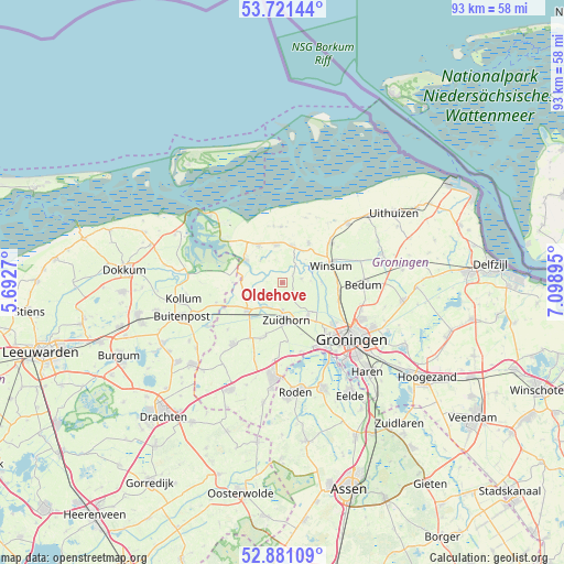
Oldehove GPS coordinates[2]
53° 18' 11.988" North, 6° 23' 44.988" East
| Map corner | latitude | longitude |
|---|---|---|
| Upper-left | 53.72144°, | 5.6927° |
| Center: | 53.30333°, | 6.39583° |
| Lower-right: | 52.88109°, | 7.09895° |
| Map W x H: | 93.4×93.4 km | = 58×58mi |
| max Lat: | 53.48025° ⇑2.3% North |
| Oldehove: | 53.30333° |
| min Lat: | ⇓97.7% South 50.76917° |
| min Long | Oldehove | max Long |
| 3.38611° | 6.39583° | 7.16528° |
| W 87.2%⇐ | ⇒12.8% E |
Elevation
Elevation of Oldehove is 2 m = 7 ft, and this is 13 m = 43 ft below average elevation for this country.
| Max E: |
203 m = 666 ft | 74.9% |
| Avg. | 15 m = 49 ft | |
| Oldehove | 2 m = 7 ft | |
Min E: |
-6 m = -20 ft | 25.1% |
See also: Netherlands elevation on elevation.city.
Geographical zone
Oldehove is located in North temperate zone (between Tropic of Cancer and the Arctic Circle). Distance of this North polar circle is 1474.4 km =916.1 mi to North.| Distance of | km | miles | from Oldehove |
|---|---|---|---|
| North Pole | 4080.3 | 2535.4 | to North |
| Arctic Circle | 1474.4 | 916.1 | to North |
| Tropic Cancer | 3320.9 | 2063.5 | to South |
| Equator | 5926.8 | 3682.7 | to South |


Nearby cities:
15 places around Oldehove: (largest is in red/bold)
• Aduard
6.7 km =4.2 mi,  140°
140°
• Eenrum
7.8 km =4.8 mi,  32°
32°
• Ezinge
3.1 km =1.9 mi,  76°
76°
• Grijpskerk
7.4 km =4.6 mi,  232°
232°
• Kloosterburen
9.3 km =5.8 mi,  358°
358°
• Kommerzijl
5.1 km =3.2 mi,  248°
248°
• Leens
6.4 km =4 mi,  350°
350°
• Niekerk
9.2 km =5.7 mi,  198°
198°
• Noordhorn
4.6 km =2.9 mi,  180°
180°
• Obergum
8.7 km =5.4 mi,  67°
67°
• Sauwerd
9.3 km =5.8 mi,  96°
96°
• Ulrum
7.5 km =4.7 mi,  326°
326°
• Winsum
8.8 km =5.5 mi, 70°
• Zoutkamp
7.3 km =4.5 mi,  303°
303°
• Zuidhorn
6.3 km =3.9 mi, 175°
Sources, notices
• [Note1] Compared only with cities in Netherlands existing in our database
• [Src1] Map data: © OpenStreetMap contributors (CC-BY-SA)
• [Src2] Other city data from geonames.org with taken over terms of usage.
• [Src3] Geographical zone / Annual Mean Temperature by Robert A. Rohde @ Wikipedia
