Vigeland geodata
Vigeland (Vest-Agder) is a seat of a second-order administrative division; located in Norway in Europe/Oslo (GMT+2) time zone. With population of 1,258 people, there are 261 cities with bigger population in this country. Compared to other cities in Norway, 99.5% of cities are located further ↑North; 71.2% of cities are located further →East and 88.6% of cities have higher elevation than Vigeland. Note1


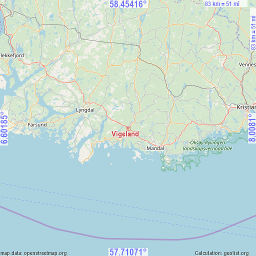
Vigeland GPS coordinates[2]
58° 5' 3.732" North, 7° 18' 17.892" East
| Map corner | latitude | longitude |
|---|---|---|
| Upper-left | 58.45416°, | 6.60185° |
| Center: | 58.08437°, | 7.30497° |
| Lower-right: | 57.71071°, | 8.0081° |
| Map W x H: | 82.7×82.7 km | = 51.4×51.4mi |
| max Lat: | 71.04137° ⇑99.5% North |
| Vigeland: | 58.08437° |
| min Lat: | ⇓0.5% South 58.0274° |
| min Long | Vigeland | max Long |
| 4.71485° | 7.30497° | 31.11066° |
| W 28.8%⇐ | ⇒71.2% E |
Elevation
Elevation of Vigeland is 5 m = 16 ft, and this is 99.2 m = 325 ft below average elevation for this country.
| Max E: |
897 m = 2943 ft | 88.6% |
| Avg. | 104.2 m = 342 ft | |
| Vigeland | 5 m = 16 ft | |
Min E: |
1 m = 3 ft | 11.4% |
See also: Norway elevation on elevation.city.
Geographical zone
Vigeland is located in North temperate zone (between Tropic of Cancer and the Arctic Circle). Distance of this North polar circle is 942.8 km =585.8 mi to North.| Distance of | km | miles | from Vigeland |
|---|---|---|---|
| North Pole | 3548.7 | 2205.1 | to North |
| Arctic Circle | 942.8 | 585.8 | to North |
| Tropic Cancer | 3852.5 | 2393.8 | to South |
| Equator | 6458.4 | 4013.1 | to South |


Nearby cities:
15 places around Vigeland: (largest is in red/bold)
• Farsund
29.4 km =18.3 mi,  272°
272°
• Helland
17.7 km =11 mi,  46°
46°
• Konsmo
22.5 km =14 mi,  7°
7°
• Kristiansand
41.1 km =25.5 mi,  80°
80°
• Liknes
32.3 km =20.1 mi,  321°
321°
• Lyngdal
15 km =9.3 mi,  293°
293°
• Mandal
10.8 km =6.7 mi,  125°
125°
• Nodeland
32.1 km =19.9 mi, 75°
• Skålevik
41.8 km =26 mi,  90°
90°
• Spangereid
10.5 km =6.5 mi,  246°
246°
• Strai
38.4 km =23.9 mi,  72°
72°
• Søgne
28.1 km =17.5 mi, 87°
• Tangvall
30 km =18.6 mi, 87°
• Tingvatn
32.8 km =20.4 mi,  351°
351°
• Vanse
36.1 km =22.4 mi, 272°
Sources, notices
• [Note1] Compared only with cities in Norway existing in our database
• [Src1] Map data: © OpenStreetMap contributors (CC-BY-SA)
• [Src2] Other city data from geonames.org with taken over terms of usage.
• [Src3] Geographical zone / Annual Mean Temperature by Robert A. Rohde @ Wikipedia
