Kristiansand geodata
Kristiansand (Vest-Agder) is a seat of a first-order administrative division; located in Norway in Europe/Oslo (GMT+2) time zone. With population of 63,814 people, there are 6 cities with bigger population in this country. Compared to other cities in Norway, 98.4% of cities are located further ↑North; 67.1% of cities are located further →East and 77.8% of cities have higher elevation than Kristiansand. Note1


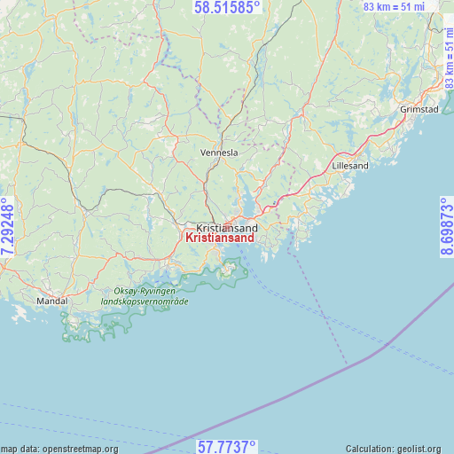
Kristiansand GPS coordinates[2]
58° 8' 48.156" North, 7° 59' 44.16" East
| Map corner | latitude | longitude |
|---|---|---|
| Upper-left | 58.51585°, | 7.29248° |
| Center: | 58.14671°, | 7.9956° |
| Lower-right: | 57.7737°, | 8.69873° |
| Map W x H: | 82.5×82.5 km | = 51.3×51.3mi |
| max Lat: | 71.04137° ⇑98.4% North |
| Kristiansand: | 58.14671° |
| min Lat: | ⇓1.6% South 58.0274° |
| min Long | Kristiansand | max Long |
| 4.71485° | 7.9956° | 31.11066° |
| W 32.9%⇐ | ⇒67.1% E |
Elevation
Elevation of Kristiansand is 12 m = 39 ft, and this is 92.2 m = 302 ft below average elevation for this country.
| Max E: |
897 m = 2943 ft | 77.8% |
| Avg. | 104.2 m = 342 ft | |
| Kristiansand | 12 m = 39 ft | |
Min E: |
1 m = 3 ft | 22.2% |
See also: Kristiansand elevation on elevation.city.
Geographical zone
Kristiansand is located in North temperate zone (between Tropic of Cancer and the Arctic Circle). Distance of this North polar circle is 935.9 km =581.5 mi to North.| Distance of | km | miles | from Kristiansand |
|---|---|---|---|
| North Pole | 3541.8 | 2200.8 | to North |
| Arctic Circle | 935.9 | 581.5 | to North |
| Tropic Cancer | 3859.4 | 2398.1 | to South |
| Equator | 6465.3 | 4017.3 | to South |


Nearby cities:
15 places around Kristiansand: (largest is in red/bold)
• Birkeland
24.7 km =15.3 mi,  34°
34°
• Birketveit
35 km =21.7 mi,  352°
352°
• Helland
28.1 km =17.5 mi,  280°
280°
• Jordtveit
33 km =20.5 mi,  65°
65°
• Justvik
6 km =3.7 mi,  20°
20°
• Konsmo
40.5 km =25.2 mi,  292°
292°
• Lillesand
25.1 km =15.6 mi,  63°
63°
• Mandal
34.5 km =21.4 mi,  247°
247°
• Nodeland
9.4 km =5.8 mi, 275°
• Skålevik
7.6 km =4.7 mi,  170°
170°
• Strai
6.2 km =3.9 mi,  320°
320°
• Søgne
13.8 km =8.6 mi,  244°
244°
• Tangvall
11.9 km =7.4 mi, 242°
• Tveit
12.2 km =7.6 mi,  37°
37°
• Vennesla
13.6 km =8.5 mi, 354°
Sources, notices
• [Note1] Compared only with cities in Norway existing in our database
• [Src1] Map data: © OpenStreetMap contributors (CC-BY-SA)
• [Src2] Other city data from geonames.org with taken over terms of usage.
• [Src3] Geographical zone / Annual Mean Temperature by Robert A. Rohde @ Wikipedia
