Helland geodata
Helland (Vest-Agder) is a seat of a second-order administrative division; located in Norway in Europe/Oslo (GMT+2) time zone. In our database, there are 488 cities with bigger population. Compared to other cities in Norway, 97.9% of cities are located further ↑North; 69.9% of cities are located further →East and 54.7% of cities have higher elevation than Helland. Note1


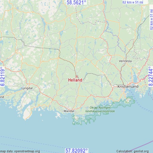
Helland GPS coordinates[2]
58° 11' 36.384" North, 7° 31' 27.516" East
| Map corner | latitude | longitude |
|---|---|---|
| Upper-left | 58.5621°, | 6.82119° |
| Center: | 58.19344°, | 7.52431° |
| Lower-right: | 57.82092°, | 8.22744° |
| Map W x H: | 82.4×82.4 km | = 51.2×51.2mi |
| max Lat: | 71.04137° ⇑97.9% North |
| Helland: | 58.19344° |
| min Lat: | ⇓2.1% South 58.0274° |
| min Long | Helland | max Long |
| 4.71485° | 7.52431° | 31.11066° |
| W 30.1%⇐ | ⇒69.9% E |
Elevation
Elevation of Helland is 35 m = 115 ft, and this is 69.2 m = 227 ft below average elevation for this country.
| Max E: |
897 m = 2943 ft | 54.7% |
| Avg. | 104.2 m = 342 ft | |
| Helland | 35 m = 115 ft | |
Min E: |
1 m = 3 ft | 45.3% |
See also: Norway elevation on elevation.city.
Geographical zone
Helland is located in North temperate zone (between Tropic of Cancer and the Arctic Circle). Distance of this North polar circle is 930.7 km =578.3 mi to North.| Distance of | km | miles | from Helland |
|---|---|---|---|
| North Pole | 3536.6 | 2197.5 | to North |
| Arctic Circle | 930.7 | 578.3 | to North |
| Tropic Cancer | 3864.6 | 2401.4 | to South |
| Equator | 6470.5 | 4020.6 | to South |


Nearby cities:
15 places around Helland: (largest is in red/bold)
• Justvik
29.7 km =18.5 mi,  89°
89°
• Konsmo
14.2 km =8.8 mi,  316°
316°
• Kristiansand
28.1 km =17.5 mi,  100°
100°
• Lyngdal
27.4 km =17 mi,  256°
256°
• Mandal
18.9 km =11.7 mi,  192°
192°
• Nodeland
18.8 km =11.7 mi, 103°
• Skålevik
31.5 km =19.6 mi,  113°
113°
• Spangereid
27.8 km =17.3 mi,  233°
233°
• Strai
23.7 km =14.7 mi, 91°
• Søgne
18.8 km =11.7 mi,  126°
126°
• Tangvall
20.1 km =12.5 mi,  121°
121°
• Tingvatn
27 km =16.8 mi, 318°
• Tveit
35.3 km =21.9 mi,  82°
82°
• Vennesla
27.6 km =17.1 mi,  72°
72°
• Vigeland
17.7 km =11 mi, 226°
Sources, notices
• [Note1] Compared only with cities in Norway existing in our database
• [Src1] Map data: © OpenStreetMap contributors (CC-BY-SA)
• [Src2] Other city data from geonames.org with taken over terms of usage.
• [Src3] Geographical zone / Annual Mean Temperature by Robert A. Rohde @ Wikipedia
