Konsmo geodata
Konsmo (Vest-Agder) is a seat of a second-order administrative division; located in Norway in Europe/Oslo (GMT+2) time zone. In our database, there are 488 cities with bigger population. Compared to other cities in Norway, 97% of cities are located further ↑North; 71% of cities are located further →East and 62.5% of cities have lower elevation than Konsmo. Note1


Konsmo GPS coordinates[2]
58° 17' 7.044" North, 7° 21' 21.528" East
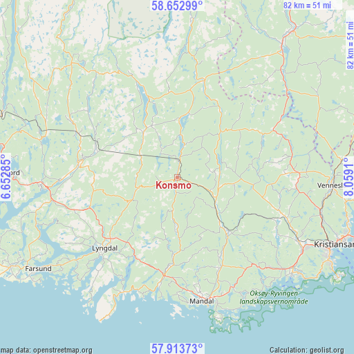
| Map corner | latitude | longitude |
|---|---|---|
| Upper-left | 58.65299°, | 6.65285° |
| Center: | 58.28529°, | 7.35598° |
| Lower-right: | 57.91373°, | 8.0591° |
| Map W x H: | 82.2×82.2 km | = 51.1×51.1mi |
| max Lat: | 71.04137° ⇑97% North |
| Konsmo: | 58.28529° |
| min Lat: | ⇓3% South 58.0274° |
| min Long | Konsmo | max Long |
| 4.71485° | 7.35598° | 31.11066° |
| W 29%⇐ | ⇒71% E |
Elevation
Elevation of Konsmo is 80 m = 262 ft, and this is 24.2 m = 79 ft below average elevation for this country.
| Max E: |
897 m = 2943 ft | 37.5% |
| Avg. | 104.2 m = 342 ft | |
| Konsmo | 80 m = 262 ft | |
Min E: |
1 m = 3 ft | 62.5% |
See also: Norway elevation on elevation.city.
Geographical zone
Konsmo is located in North temperate zone (between Tropic of Cancer and the Arctic Circle). Distance of this North polar circle is 920.5 km =572 mi to North.| Distance of | km | miles | from Konsmo |
|---|---|---|---|
| North Pole | 3526.3 | 2191.1 | to North |
| Arctic Circle | 920.5 | 572 | to North |
| Tropic Cancer | 3874.8 | 2407.7 | to South |
| Equator | 6480.7 | 4026.9 | to South |


Nearby cities:
15 places around Konsmo: (largest is in red/bold)
• Birketveit
38 km =23.6 mi,  59°
59°
• Farsund
38.6 km =24 mi,  236°
236°
• Helland
14.2 km =8.8 mi,  136°
136°
• Kyrkjebygda
36.8 km =22.9 mi,  5°
5°
• Liknes
23.2 km =14.4 mi,  277°
277°
• Lyngdal
23.5 km =14.6 mi,  225°
225°
• Mandal
29.2 km =18.1 mi,  168°
168°
• Nodeland
31.6 km =19.6 mi,  117°
117°
• Spangereid
29.4 km =18.3 mi,  205°
205°
• Strai
35.2 km =21.9 mi,  107°
107°
• Søgne
32.9 km =20.4 mi,  130°
130°
• Tangvall
34 km =21.1 mi, 127°
• Tingvatn
12.8 km =8 mi,  321°
321°
• Vennesla
36.1 km =22.4 mi,  92°
92°
• Vigeland
22.5 km =14 mi,  187°
187°
Sources, notices
• [Note1] Compared only with cities in Norway existing in our database
• [Src1] Map data: © OpenStreetMap contributors (CC-BY-SA)
• [Src2] Other city data from geonames.org with taken over terms of usage.
• [Src3] Geographical zone / Annual Mean Temperature by Robert A. Rohde @ Wikipedia
