Skålevik geodata
Skålevik (Vest-Agder) is a populated locality; located in Norway in Europe/Oslo (GMT+2) time zone. With population of 2,599 people, there are 145 cities with bigger population in this country. Compared to other cities in Norway, 99.7% of cities are located further ↑North; 66.6% of cities are located further →East and 86.1% of cities have higher elevation than Skålevik. Note1


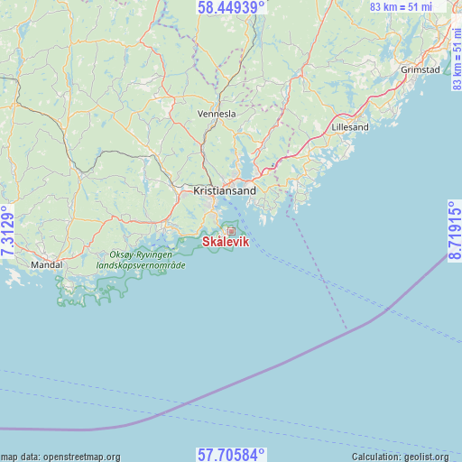
Skålevik GPS coordinates[2]
58° 4' 46.38" North, 8° 0' 57.672" East
| Map corner | latitude | longitude |
|---|---|---|
| Upper-left | 58.44939°, | 7.3129° |
| Center: | 58.07955°, | 8.01602° |
| Lower-right: | 57.70584°, | 8.71915° |
| Map W x H: | 82.7×82.7 km | = 51.4×51.4mi |
| max Lat: | 71.04137° ⇑99.7% North |
| Skålevik: | 58.07955° |
| min Lat: | ⇓0.3% South 58.0274° |
| min Long | Skålevik | max Long |
| 4.71485° | 8.01602° | 31.11066° |
| W 33.4%⇐ | ⇒66.6% E |
Elevation
Elevation of Skålevik is 7 m = 23 ft, and this is 97.2 m = 319 ft below average elevation for this country.
| Max E: |
897 m = 2943 ft | 86.1% |
| Avg. | 104.2 m = 342 ft | |
| Skålevik | 7 m = 23 ft | |
Min E: |
1 m = 3 ft | 13.9% |
See also: Norway elevation on elevation.city.
Geographical zone
Skålevik is located in North temperate zone (between Tropic of Cancer and the Arctic Circle). Distance of this North polar circle is 943.3 km =586.1 mi to North.| Distance of | km | miles | from Skålevik |
|---|---|---|---|
| North Pole | 3549.2 | 2205.4 | to North |
| Arctic Circle | 943.3 | 586.1 | to North |
| Tropic Cancer | 3851.9 | 2393.5 | to South |
| Equator | 6457.8 | 4012.7 | to South |


Nearby cities:
15 places around Skålevik: (largest is in red/bold)
• Birkeland
30.7 km =19.1 mi,  24°
24°
• Birketveit
42.6 km =26.5 mi,  352°
352°
• Helland
31.5 km =19.6 mi,  293°
293°
• Jordtveit
35.8 km =22.2 mi,  53°
53°
• Justvik
13.1 km =8.1 mi,  3°
3°
• Kristiansand
7.6 km =4.7 mi, 350°
• Lillesand
28.4 km =17.6 mi, 48°
• Mandal
33.6 km =20.9 mi,  260°
260°
• Nodeland
13.5 km =8.4 mi,  308°
308°
• Strai
13.2 km =8.2 mi,  337°
337°
• Søgne
13.8 km =8.6 mi,  276°
276°
• Tangvall
12 km =7.5 mi, 279°
• Tveit
18.2 km =11.3 mi, 19°
• Vennesla
21.2 km =13.2 mi, 353°
• Vigeland
41.8 km =26 mi,  270°
270°
Sources, notices
• [Note1] Compared only with cities in Norway existing in our database
• [Src1] Map data: © OpenStreetMap contributors (CC-BY-SA)
• [Src2] Other city data from geonames.org with taken over terms of usage.
• [Src3] Geographical zone / Annual Mean Temperature by Robert A. Rohde @ Wikipedia
