Holmestrand geodata
Holmestrand (Vestfold) is a seat of a second-order administrative division; located in Norway in Europe/Oslo (GMT+2) time zone. With population of 6,135 people, there are 71 cities with bigger population in this country. Compared to other cities in Norway, 78.6% of cities are located further ↑North; 54.6% of cities are located further ←West and 74.4% of cities have higher elevation than Holmestrand. Note1


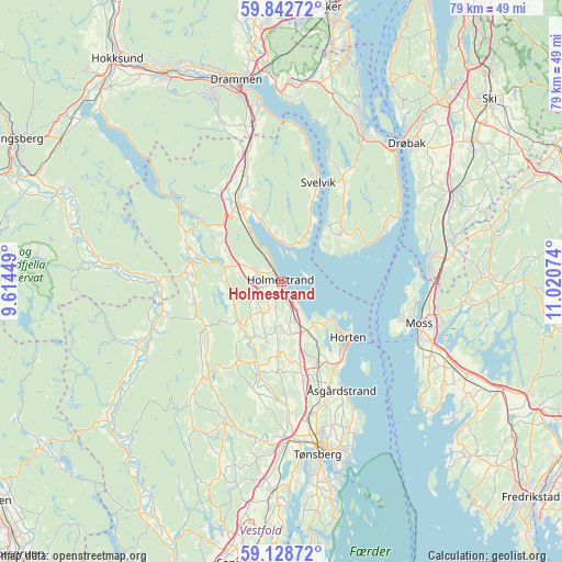
Holmestrand GPS coordinates[2]
59° 29' 15.396" North, 10° 19' 3.396" East
| Map corner | latitude | longitude |
|---|---|---|
| Upper-left | 59.84272°, | 9.61449° |
| Center: | 59.48761°, | 10.31761° |
| Lower-right: | 59.12872°, | 11.02074° |
| Map W x H: | 79.4×79.4 km | = 49.3×49.3mi |
| max Lat: | 71.04137° ⇑78.6% North |
| Holmestrand: | 59.48761° |
| min Lat: | ⇓21.4% South 58.0274° |
| min Long | Holmestrand | max Long |
| 4.71485° | 10.31761° | 31.11066° |
| W 54.6%⇐ | ⇒45.4% E |
Elevation
Elevation of Holmestrand is 14 m = 46 ft, and this is 90.2 m = 296 ft below average elevation for this country.
| Max E: |
897 m = 2943 ft | 74.4% |
| Avg. | 104.2 m = 342 ft | |
| Holmestrand | 14 m = 46 ft | |
Min E: |
1 m = 3 ft | 25.6% |
See also: Norway elevation on elevation.city.
Geographical zone
Holmestrand is located in North temperate zone (between Tropic of Cancer and the Arctic Circle). Distance of this North polar circle is 786.8 km =488.9 mi to North.| Distance of | km | miles | from Holmestrand |
|---|---|---|---|
| North Pole | 3392.7 | 2108.1 | to North |
| Arctic Circle | 786.8 | 488.9 | to North |
| Tropic Cancer | 4008.5 | 2490.8 | to South |
| Equator | 6614.4 | 4110 | to South |


Nearby cities:
15 places around Holmestrand: (largest is in red/bold)
• Andebu
21.7 km =13.5 mi,  201°
201°
• Barkåker
19.2 km =11.9 mi,  167°
167°
• Berger
7.9 km =4.9 mi,  29°
29°
• Gullhaug
4 km =2.5 mi,  292°
292°
• Horten
12.2 km =7.6 mi,  129°
129°
• Hvittingfoss
17.3 km =10.7 mi,  269°
269°
• Moss
20.1 km =12.5 mi,  107°
107°
• Nykirke
8.1 km =5 mi,  152°
152°
• Revetal
13.2 km =8.2 mi,  193°
193°
• Sande
12.6 km =7.8 mi,  330°
330°
• Selvik
9.3 km =5.8 mi,  339°
339°
• Skoppum
12.5 km =7.8 mi, 154°
• Svelvik
14.9 km =9.3 mi,  20°
20°
• Tofte
15.1 km =9.4 mi,  65°
65°
• Åsgårdstrand
17.6 km =10.9 mi, 150°
Sources, notices
• [Note1] Compared only with cities in Norway existing in our database
• [Src1] Map data: © OpenStreetMap contributors (CC-BY-SA)
• [Src2] Other city data from geonames.org with taken over terms of usage.
• [Src3] Geographical zone / Annual Mean Temperature by Robert A. Rohde @ Wikipedia
