Borgheim geodata
Borgheim (Vestfold) is a seat of a second-order administrative division; located in Norway in Europe/Oslo (GMT+2) time zone. In our database, there are 488 cities with bigger population. Compared to other cities in Norway, 85.6% of cities are located further ↑North; 56.3% of cities are located further ←West and 70.6% of cities have higher elevation than Borgheim. Note1


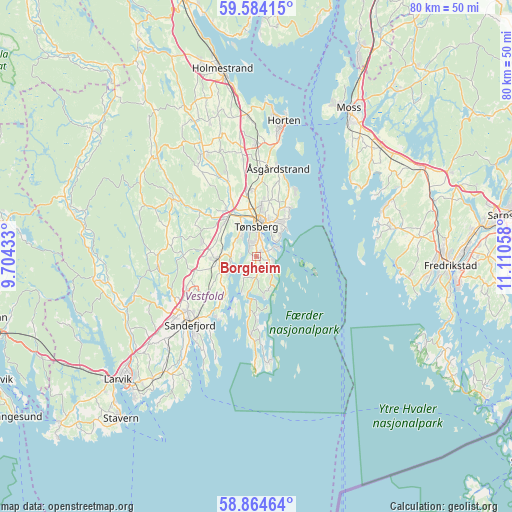
Borgheim GPS coordinates[2]
59° 13' 34.644" North, 10° 24' 26.82" East
| Map corner | latitude | longitude |
|---|---|---|
| Upper-left | 59.58415°, | 9.70433° |
| Center: | 59.22629°, | 10.40745° |
| Lower-right: | 58.86464°, | 11.11058° |
| Map W x H: | 80×80 km | = 49.7×49.7mi |
| max Lat: | 71.04137° ⇑85.6% North |
| Borgheim: | 59.22629° |
| min Lat: | ⇓14.4% South 58.0274° |
| min Long | Borgheim | max Long |
| 4.71485° | 10.40745° | 31.11066° |
| W 56.3%⇐ | ⇒43.7% E |
Elevation
Elevation of Borgheim is 18 m = 59 ft, and this is 86.2 m = 283 ft below average elevation for this country.
| Max E: |
897 m = 2943 ft | 70.6% |
| Avg. | 104.2 m = 342 ft | |
| Borgheim | 18 m = 59 ft | |
Min E: |
1 m = 3 ft | 29.4% |
See also: Norway elevation on elevation.city.
Geographical zone
Borgheim is located in North temperate zone (between Tropic of Cancer and the Arctic Circle). Distance of this North polar circle is 815.8 km =506.9 mi to North.| Distance of | km | miles | from Borgheim |
|---|---|---|---|
| North Pole | 3421.7 | 2126.1 | to North |
| Arctic Circle | 815.8 | 506.9 | to North |
| Tropic Cancer | 3979.4 | 2472.7 | to South |
| Equator | 6585.3 | 4091.9 | to South |


Nearby cities:
15 places around Borgheim: (largest is in red/bold)
• Andebu
15.8 km =9.8 mi,  304°
304°
• Barkåker
10.3 km =6.4 mi,  354°
354°
• Horten
21.7 km =13.5 mi,  11°
11°
• Larkollen
18.8 km =11.7 mi,  51°
51°
• Lervik
19.9 km =12.4 mi,  75°
75°
• Melsomvik
4.1 km =2.5 mi,  266°
266°
• Revetal
18.2 km =11.3 mi,  333°
333°
• Sandefjord
15.2 km =9.4 mi,  225°
225°
• Sem
7.6 km =4.7 mi,  324°
324°
• Skoppum
17.8 km =11.1 mi,  0°
0°
• Stokke
6.1 km =3.8 mi, 266°
• Tjøme
12.9 km =8 mi,  183°
183°
• Tønsberg
4.6 km =2.9 mi, 0°
• Årøysund
5.6 km =3.5 mi,  149°
149°
• Åsgårdstrand
14.1 km =8.8 mi, 14°
Sources, notices
• [Note1] Compared only with cities in Norway existing in our database
• [Src1] Map data: © OpenStreetMap contributors (CC-BY-SA)
• [Src2] Other city data from geonames.org with taken over terms of usage.
• [Src3] Geographical zone / Annual Mean Temperature by Robert A. Rohde @ Wikipedia
