Revetal geodata
Revetal (Vestfold) is a seat of a second-order administrative division; located in Norway in Europe/Oslo (GMT+2) time zone. In our database, there are 488 cities with bigger population. Compared to other cities in Norway, 81.8% of cities are located further ↑North; 53% of cities are located further ←West and 58.7% of cities have higher elevation than Revetal. Note1


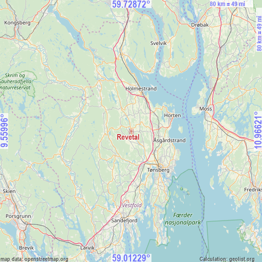
Revetal GPS coordinates[2]
59° 22' 20.64" North, 10° 15' 47.088" East
| Map corner | latitude | longitude |
|---|---|---|
| Upper-left | 59.72872°, | 9.55996° |
| Center: | 59.3724°, | 10.26308° |
| Lower-right: | 59.01229°, | 10.96621° |
| Map W x H: | 79.7×79.7 km | = 49.5×49.5mi |
| max Lat: | 71.04137° ⇑81.8% North |
| Revetal: | 59.3724° |
| min Lat: | ⇓18.2% South 58.0274° |
| min Long | Revetal | max Long |
| 4.71485° | 10.26308° | 31.11066° |
| W 53%⇐ | ⇒47% E |
Elevation
Elevation of Revetal is 29 m = 95 ft, and this is 75.2 m = 247 ft below average elevation for this country.
| Max E: |
897 m = 2943 ft | 58.7% |
| Avg. | 104.2 m = 342 ft | |
| Revetal | 29 m = 95 ft | |
Min E: |
1 m = 3 ft | 41.3% |
See also: Norway elevation on elevation.city.
Geographical zone
Revetal is located in North temperate zone (between Tropic of Cancer and the Arctic Circle). Distance of this North polar circle is 799.6 km =496.8 mi to North.| Distance of | km | miles | from Revetal |
|---|---|---|---|
| North Pole | 3405.5 | 2116.1 | to North |
| Arctic Circle | 799.6 | 496.8 | to North |
| Tropic Cancer | 3995.7 | 2482.8 | to South |
| Equator | 6601.6 | 4102 | to South |


Nearby cities:
15 places around Revetal: (largest is in red/bold)
• Andebu
8.9 km =5.5 mi,  213°
213°
• Barkåker
9.3 km =5.8 mi,  129°
129°
• Berger
20.9 km =13 mi,  19°
19°
• Borgheim
18.2 km =11.3 mi,  153°
153°
• Gullhaug
14.3 km =8.9 mi,  357°
357°
• Holmestrand
13.2 km =8.2 mi,  13°
13°
• Horten
13.4 km =8.3 mi,  68°
68°
• Hvittingfoss
19 km =11.8 mi,  311°
311°
• Melsomvik
17 km =10.6 mi,  165°
165°
• Nykirke
8.9 km =5.5 mi,  50°
50°
• Sem
10.7 km =6.6 mi,  159°
159°
• Skoppum
8.5 km =5.3 mi,  79°
79°
• Stokke
16.8 km =10.4 mi, 172°
• Tønsberg
14.3 km =8.9 mi,  144°
144°
• Åsgårdstrand
12 km =7.5 mi,  102°
102°
Sources, notices
• [Note1] Compared only with cities in Norway existing in our database
• [Src1] Map data: © OpenStreetMap contributors (CC-BY-SA)
• [Src2] Other city data from geonames.org with taken over terms of usage.
• [Src3] Geographical zone / Annual Mean Temperature by Robert A. Rohde @ Wikipedia
