Valldal geodata
Valldal (Møre og Romsdal) is a seat of a second-order administrative division; located in Norway in Europe/Oslo (GMT+2) time zone. In our database, there are 488 cities with bigger population. Compared to other cities in Norway, 65.8% of cities are located further ↓South; 71.5% of cities are located further →East and 71.2% of cities have higher elevation than Valldal. Note1


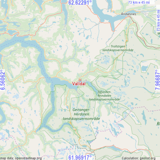
Valldal GPS coordinates[2]
62° 17' 52.152" North, 7° 15' 49.464" East
| Map corner | latitude | longitude |
|---|---|---|
| Upper-left | 62.62291°, | 6.56062° |
| Center: | 62.29782°, | 7.26374° |
| Lower-right: | 61.96917°, | 7.96687° |
| Map W x H: | 72.7×72.7 km | = 45.2×45.2mi |
| max Lat: | 71.04137° ⇑34.2% North |
| Valldal: | 62.29782° |
| min Lat: | ⇓65.8% South 58.0274° |
| min Long | Valldal | max Long |
| 4.71485° | 7.26374° | 31.11066° |
| W 28.5%⇐ | ⇒71.5% E |
Elevation
Elevation of Valldal is 17 m = 56 ft, and this is 87.2 m = 286 ft below average elevation for this country.
| Max E: |
897 m = 2943 ft | 71.2% |
| Avg. | 104.2 m = 342 ft | |
| Valldal | 17 m = 56 ft | |
Min E: |
1 m = 3 ft | 28.8% |
See also: Norway elevation on elevation.city.
Geographical zone
Valldal is located in North temperate zone (between Tropic of Cancer and the Arctic Circle). Distance of this North polar circle is 474.3 km =294.7 mi to North.| Distance of | km | miles | from Valldal |
|---|---|---|---|
| North Pole | 3080.2 | 1913.9 | to North |
| Arctic Circle | 474.3 | 294.7 | to North |
| Tropic Cancer | 4320.9 | 2684.9 | to South |
| Equator | 6926.9 | 4304.2 | to South |


Nearby cities:
15 places around Valldal: (largest is in red/bold)
• Giskemo
29.1 km =18.1 mi,  315°
315°
• Hornindal
53 km =32.9 mi,  226°
226°
• Ikornnes
38.1 km =23.7 mi,  284°
284°
• Midsund
51.6 km =32.1 mi, 324°
• Molde
49.2 km =30.6 mi,  353°
353°
• Sjøholt
31 km =19.3 mi,  311°
311°
• Skodje
37.3 km =23.2 mi, 308°
• Stordal
17.1 km =10.6 mi,  303°
303°
• Stranda
16.9 km =10.5 mi,  274°
274°
• Stryn
52.3 km =32.5 mi,  212°
212°
• Sykkylven
36.6 km =22.7 mi,  287°
287°
• Tomra
35.9 km =22.3 mi,  331°
331°
• Vatne
44.1 km =27.4 mi, 311°
• Vestnes
37.5 km =23.3 mi, 345°
• Åndalsnes
37.1 km =23.1 mi,  35°
35°
Sources, notices
• [Note1] Compared only with cities in Norway existing in our database
• [Src1] Map data: © OpenStreetMap contributors (CC-BY-SA)
• [Src2] Other city data from geonames.org with taken over terms of usage.
• [Src3] Geographical zone / Annual Mean Temperature by Robert A. Rohde @ Wikipedia
