Vestnes geodata
Vestnes (Møre og Romsdal) is a seat of a second-order administrative division; located in Norway in Europe/Oslo (GMT+2) time zone. With population of 2,088 people, there are 194 cities with bigger population in this country. Compared to other cities in Norway, 69.9% of cities are located further ↓South; 72.9% of cities are located further →East and 100% of cities have higher elevation than Vestnes. Note1


Vestnes GPS coordinates[2]
62° 37' 31.584" North, 7° 5' 13.056" East
| Map corner | latitude | longitude |
|---|---|---|
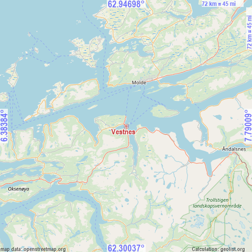
| Upper-left | 62.94698°, | 6.38384° |
| Center: | 62.62544°, | 7.08696° |
| Lower-right: | 62.30037°, | 7.79009° |
| Map W x H: | 71.9×71.9 km | = 44.7×44.7mi |
| max Lat: | 71.04137° ⇑30.1% North |
| Vestnes: | 62.62544° |
| min Lat: | ⇓69.9% South 58.0274° |
| min Long | Vestnes | max Long |
| 4.71485° | 7.08696° | 31.11066° |
| W 27.1%⇐ | ⇒72.9% E |
Elevation
Elevation of Vestnes is 1 m = 3 ft, and this is 103.2 m = 339 ft below average elevation for this country.
| Max E: |
897 m = 2943 ft | 100% |
| Avg. | 104.2 m = 342 ft | |
| Vestnes | 1 m = 3 ft | |
Min E: |
1 m = 3 ft | 0% |
See also: Norway elevation on elevation.city.
Geographical zone
Vestnes is located in North temperate zone (between Tropic of Cancer and the Arctic Circle). Distance of this North polar circle is 437.9 km =272.1 mi to North.| Distance of | km | miles | from Vestnes |
|---|---|---|---|
| North Pole | 3043.8 | 1891.3 | to North |
| Arctic Circle | 437.9 | 272.1 | to North |
| Tropic Cancer | 4357.4 | 2707.6 | to South |
| Equator | 6963.3 | 4326.8 | to South |


Nearby cities:
15 places around Vestnes: (largest is in red/bold)
• Aukra
20 km =12.4 mi,  331°
331°
• Brattvåg
33 km =20.5 mi,  265°
265°
• Bud
32.5 km =20.2 mi,  344°
344°
• Elnesvågen
25.6 km =15.9 mi,  5°
5°
• Falkhytta
22.4 km =13.9 mi, 332°
• Giskemo
19.4 km =12.1 mi,  215°
215°
• Hjelset
26.9 km =16.7 mi,  50°
50°
• Midsund
21.8 km =13.5 mi,  284°
284°
• Molde
13 km =8.1 mi,  16°
16°
• Sjøholt
21.2 km =13.2 mi, 221°
• Skodje
24.2 km =15 mi,  236°
236°
• Stordal
27.6 km =17.1 mi,  190°
190°
• Tomra
9.4 km =5.8 mi, 238°
• Vatne
25.2 km =15.7 mi,  252°
252°
• Åndalsnes
31.4 km =19.5 mi,  101°
101°
Sources, notices
• [Note1] Compared only with cities in Norway existing in our database
• [Src1] Map data: © OpenStreetMap contributors (CC-BY-SA)
• [Src2] Other city data from geonames.org with taken over terms of usage.
• [Src3] Geographical zone / Annual Mean Temperature by Robert A. Rohde @ Wikipedia
