Midsund geodata
Midsund (Møre og Romsdal) is a seat of a second-order administrative division; located in Norway in Europe/Oslo (GMT+2) time zone. With population of 468 people, there are 463 cities with bigger population in this country. Compared to other cities in Norway, 70.3% of cities are located further ↓South; 76.3% of cities are located further →East and 58.2% of cities have higher elevation than Midsund. Note1


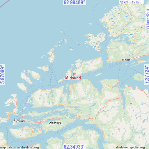
Midsund GPS coordinates[2]
62° 40' 25.932" North, 6° 40' 26.832" East
| Map corner | latitude | longitude |
|---|---|---|
| Upper-left | 62.99489°, | 5.97099° |
| Center: | 62.67387°, | 6.67412° |
| Lower-right: | 62.34933°, | 7.37724° |
| Map W x H: | 71.8×71.8 km | = 44.6×44.6mi |
| max Lat: | 71.04137° ⇑29.7% North |
| Midsund: | 62.67387° |
| min Lat: | ⇓70.3% South 58.0274° |
| min Long | Midsund | max Long |
| 4.71485° | 6.67412° | 31.11066° |
| W 23.7%⇐ | ⇒76.3% E |
Elevation
Elevation of Midsund is 30 m = 98 ft, and this is 74.2 m = 243 ft below average elevation for this country.
| Max E: |
897 m = 2943 ft | 58.2% |
| Avg. | 104.2 m = 342 ft | |
| Midsund | 30 m = 98 ft | |
Min E: |
1 m = 3 ft | 41.8% |
See also: Norway elevation on elevation.city.
Geographical zone
Midsund is located in North temperate zone (between Tropic of Cancer and the Arctic Circle). Distance of this North polar circle is 432.5 km =268.7 mi to North.| Distance of | km | miles | from Midsund |
|---|---|---|---|
| North Pole | 3038.4 | 1888 | to North |
| Arctic Circle | 432.5 | 268.7 | to North |
| Tropic Cancer | 4362.8 | 2710.9 | to South |
| Equator | 6968.7 | 4330.1 | to South |


Nearby cities:
15 places around Midsund: (largest is in red/bold)
• Aukra
16.8 km =10.4 mi,  43°
43°
• Brattvåg
14.3 km =8.9 mi,  235°
235°
• Bud
28.7 km =17.8 mi,  25°
25°
• Elnesvågen
31 km =19.3 mi,  49°
49°
• Falkhytta
18.2 km =11.3 mi, 36°
• Giskemo
23.4 km =14.5 mi,  155°
155°
• Molde
25.7 km =16 mi,  74°
74°
• Roald
29.9 km =18.6 mi,  250°
250°
• Sjøholt
22.4 km =13.9 mi, 161°
• Skodje
18.8 km =11.7 mi,  177°
177°
• Steinshamn
16 km =9.9 mi,  319°
319°
• Syvik
23.6 km =14.7 mi,  234°
234°
• Tomra
16.7 km =10.4 mi,  128°
128°
• Vatne
13.2 km =8.2 mi,  192°
192°
• Vestnes
21.8 km =13.5 mi,  104°
104°
Sources, notices
• [Note1] Compared only with cities in Norway existing in our database
• [Src1] Map data: © OpenStreetMap contributors (CC-BY-SA)
• [Src2] Other city data from geonames.org with taken over terms of usage.
• [Src3] Geographical zone / Annual Mean Temperature by Robert A. Rohde @ Wikipedia
