Kolbotn geodata
Kolbotn (Akershus) is a seat of a second-order administrative division; located in Norway in Europe/Oslo (GMT+2) time zone. In our database, there are 488 cities with bigger population. Compared to other cities in Norway, 69.6% of cities are located further ↑North; 64.2% of cities are located further ←West and 67.9% of cities have lower elevation than Kolbotn. Note1


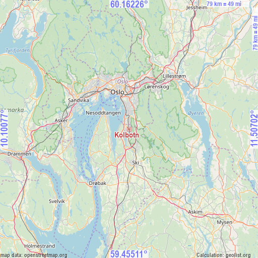
Kolbotn GPS coordinates[2]
59° 48' 38.016" North, 10° 48' 14.004" East
| Map corner | latitude | longitude |
|---|---|---|
| Upper-left | 60.16226°, | 10.10077° |
| Center: | 59.81056°, | 10.80389° |
| Lower-right: | 59.45511°, | 11.50702° |
| Map W x H: | 78.6×78.6 km | = 48.8×48.8mi |
| max Lat: | 71.04137° ⇑69.6% North |
| Kolbotn: | 59.81056° |
| min Lat: | ⇓30.4% South 58.0274° |
| min Long | Kolbotn | max Long |
| 4.71485° | 10.80389° | 31.11066° |
| W 64.2%⇐ | ⇒35.8% E |
Elevation
Elevation of Kolbotn is 112 m = 367 ft, and this is 7.8 m = 26 ft above average elevation for this country.
| Max E: |
897 m = 2943 ft | 32.1% |
| Kolbotn | 112 m 367 ft | |
| Avg. | 104.2 m = 342 ft | |
Min E: |
1 m = 3 ft | 67.9% |
See also: Norway elevation on elevation.city.
Geographical zone
Kolbotn is located in North temperate zone (between Tropic of Cancer and the Arctic Circle). Distance of this North polar circle is 750.9 km =466.6 mi to North.| Distance of | km | miles | from Kolbotn |
|---|---|---|---|
| North Pole | 3356.8 | 2085.8 | to North |
| Arctic Circle | 750.9 | 466.6 | to North |
| Tropic Cancer | 4044.4 | 2513.1 | to South |
| Equator | 6650.3 | 4132.3 | to South |


Nearby cities:
15 places around Kolbotn: (largest is in red/bold)
• Billingstad
19.4 km =12.1 mi,  291°
291°
• Blakstad
19 km =11.8 mi,  272°
272°
• Drøbak
19.1 km =11.9 mi,  210°
210°
• Fagerstrand
14.3 km =8.9 mi,  235°
235°
• Fjellstrand
11.2 km =7 mi,  260°
260°
• Fjerdingby
19.5 km =12.1 mi,  48°
48°
• Kjenn
15.8 km =9.8 mi,  31°
31°
• Lysaker
14.5 km =9 mi,  319°
319°
• Nesoddtangen
9.8 km =6.1 mi,  306°
306°
• Oslo
11.8 km =7.3 mi,  344°
344°
• Sandvika
17.8 km =11.1 mi,  300°
300°
• Sjølyststranda
14.1 km =8.8 mi,  330°
330°
• Ski
10.3 km =6.4 mi,  170°
170°
• Slemmestad
17.5 km =10.9 mi, 259°
• Ås
16.2 km =10.1 mi,  181°
181°
Sources, notices
• [Note1] Compared only with cities in Norway existing in our database
• [Src1] Map data: © OpenStreetMap contributors (CC-BY-SA)
• [Src2] Other city data from geonames.org with taken over terms of usage.
• [Src3] Geographical zone / Annual Mean Temperature by Robert A. Rohde @ Wikipedia
