Oslo geodata
Oslo is a capital of a political entity; located in Norway in Europe/Oslo (GMT+2) time zone. With population of 580,000 people, there are 0 cities with bigger population in this country. Compared to other cities in Norway, 67.4% of cities are located further ↑North; 63% of cities are located further ←West and 61.1% of cities have higher elevation than Oslo. Note1


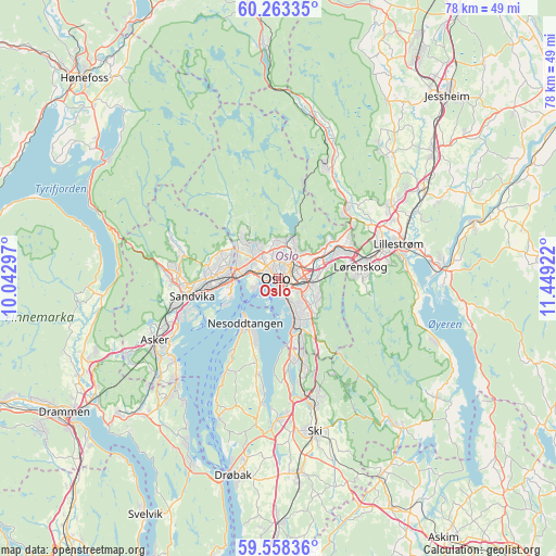
Oslo GPS coordinates[2]
59° 54' 45.828" North, 10° 44' 45.924" East
| Map corner | latitude | longitude |
|---|---|---|
| Upper-left | 60.26335°, | 10.04297° |
| Center: | 59.91273°, | 10.74609° |
| Lower-right: | 59.55836°, | 11.44922° |
| Map W x H: | 78.4×78.4 km | = 48.7×48.7mi |
| max Lat: | 71.04137° ⇑67.4% North |
| Oslo: | 59.91273° |
| min Lat: | ⇓32.6% South 58.0274° |
| min Long | Oslo | max Long |
| 4.71485° | 10.74609° | 31.11066° |
| W 63%⇐ | ⇒37% E |
Elevation
Elevation of Oslo is 26 m = 85 ft, and this is 78.2 m = 257 ft below average elevation for this country.
| Max E: |
897 m = 2943 ft | 61.1% |
| Avg. | 104.2 m = 342 ft | |
| Oslo | 26 m = 85 ft | |
Min E: |
1 m = 3 ft | 38.9% |
See also: Oslo elevation on elevation.city.
Geographical zone
Oslo is located in North temperate zone (between Tropic of Cancer and the Arctic Circle). Distance of this North polar circle is 739.5 km =459.5 mi to North.| Distance of | km | miles | from Oslo |
|---|---|---|---|
| North Pole | 3345.4 | 2078.7 | to North |
| Arctic Circle | 739.5 | 459.5 | to North |
| Tropic Cancer | 4055.8 | 2520.2 | to South |
| Equator | 6661.7 | 4139.4 | to South |


Nearby cities:
15 places around Oslo: (largest is in red/bold)
• Asker
19.4 km =12.1 mi,  242°
242°
• Billingstad
15.3 km =9.5 mi,  254°
254°
• Blakstad
18.9 km =11.7 mi, 236°
• Fjellstrand
15.3 km =9.5 mi,  210°
210°
• Fjerdingby
17.9 km =11.1 mi,  85°
85°
• Kjenn
11.7 km =7.3 mi,  80°
80°
• Kolbotn
11.8 km =7.3 mi,  164°
164°
• Lillestrøm
17.6 km =10.9 mi,  74°
74°
• Lysaker
6.2 km =3.9 mi,  267°
267°
• Nesoddtangen
7.3 km =4.5 mi,  219°
219°
• Rotnes
17.3 km =10.7 mi,  21°
21°
• Sandvika
12.4 km =7.7 mi,  258°
258°
• Sjølyststranda
3.8 km =2.4 mi,  284°
284°
• Skui
16.7 km =10.4 mi, 275°
• Smestad
17.6 km =10.9 mi, 277°
Sources, notices
• [Note1] Compared only with cities in Norway existing in our database
• [Src1] Map data: © OpenStreetMap contributors (CC-BY-SA)
• [Src2] Other city data from geonames.org with taken over terms of usage.
• [Src3] Geographical zone / Annual Mean Temperature by Robert A. Rohde @ Wikipedia
