Sjølyststranda geodata
Sjølyststranda (Oslo) is a section of populated place; located in Norway in Europe/Oslo (GMT+2) time zone. With population of 1,500 people, there are 240 cities with bigger population in this country. Compared to other cities in Norway, 67.1% of cities are located further ↑North; 62% of cities are located further ←West and 75.8% of cities have higher elevation than Sjølyststranda. Note1


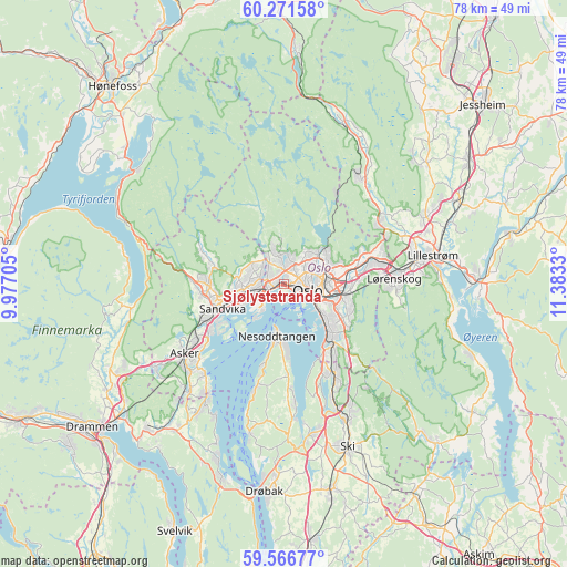
Sjølyststranda GPS coordinates[2]
59° 55' 15.78" North, 10° 40' 48.612" East
| Map corner | latitude | longitude |
|---|---|---|
| Upper-left | 60.27158°, | 9.97705° |
| Center: | 59.92105°, | 10.68017° |
| Lower-right: | 59.56677°, | 11.3833° |
| Map W x H: | 78.4×78.4 km | = 48.7×48.7mi |
| max Lat: | 71.04137° ⇑67.1% North |
| Sjølyststranda: | 59.92105° |
| min Lat: | ⇓32.9% South 58.0274° |
| min Long | Sjølyststranda | max Long |
| 4.71485° | 10.68017° | 31.11066° |
| W 62%⇐ | ⇒38% E |
Elevation
Elevation of Sjølyststranda is 13 m = 43 ft, and this is 91.2 m = 299 ft below average elevation for this country.
| Max E: |
897 m = 2943 ft | 75.8% |
| Avg. | 104.2 m = 342 ft | |
| Sjølyststranda | 13 m = 43 ft | |
Min E: |
1 m = 3 ft | 24.2% |
See also: Norway elevation on elevation.city.
Geographical zone
Sjølyststranda is located in North temperate zone (between Tropic of Cancer and the Arctic Circle). Distance of this North polar circle is 738.6 km =458.9 mi to North.| Distance of | km | miles | from Sjølyststranda |
|---|---|---|---|
| North Pole | 3344.5 | 2078.2 | to North |
| Arctic Circle | 738.6 | 458.9 | to North |
| Tropic Cancer | 4056.7 | 2520.7 | to South |
| Equator | 6662.6 | 4139.9 | to South |


Nearby cities:
15 places around Sjølyststranda: (largest is in red/bold)
• Asker
16.7 km =10.4 mi,  234°
234°
• Billingstad
12.1 km =7.5 mi,  245°
245°
• Blakstad
16.5 km =10.3 mi, 226°
• Fjellstrand
14.7 km =9.1 mi,  196°
196°
• Kjenn
15.3 km =9.5 mi,  85°
85°
• Kolbotn
14.1 km =8.8 mi,  150°
150°
• Lillestrøm
20.9 km =13 mi,  79°
79°
• Lysaker
2.8 km =1.7 mi,  243°
243°
• Nesoddtangen
6.6 km =4.1 mi,  188°
188°
• Oslo
3.8 km =2.4 mi,  104°
104°
• Rotnes
18.2 km =11.3 mi,  33°
33°
• Sandvika
9.1 km =5.7 mi, 248°
• Skui
13 km =8.1 mi,  273°
273°
• Slemmestad
18.7 km =11.6 mi,  213°
213°
• Smestad
13.8 km =8.6 mi,  275°
275°
Sources, notices
• [Note1] Compared only with cities in Norway existing in our database
• [Src1] Map data: © OpenStreetMap contributors (CC-BY-SA)
• [Src2] Other city data from geonames.org with taken over terms of usage.
• [Src3] Geographical zone / Annual Mean Temperature by Robert A. Rohde @ Wikipedia
