Sandefjord geodata
Sandefjord (Vestfold) is a seat of a second-order administrative division; located in Norway in Europe/Oslo (GMT+2) time zone. With population of 42,654 people, there are 13 cities with bigger population in this country. Compared to other cities in Norway, 88% of cities are located further ↑North; 50.9% of cities are located further ←West and 79% of cities have higher elevation than Sandefjord. Note1


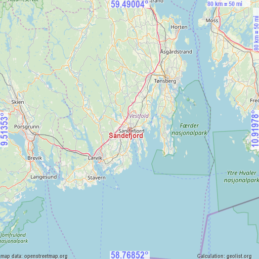
Sandefjord GPS coordinates[2]
59° 7' 52.248" North, 10° 12' 59.94" East
| Map corner | latitude | longitude |
|---|---|---|
| Upper-left | 59.49004°, | 9.51353° |
| Center: | 59.13118°, | 10.21665° |
| Lower-right: | 58.76852°, | 10.91978° |
| Map W x H: | 80.2×80.2 km | = 49.8×49.8mi |
| max Lat: | 71.04137° ⇑88% North |
| Sandefjord: | 59.13118° |
| min Lat: | ⇓12% South 58.0274° |
| min Long | Sandefjord | max Long |
| 4.71485° | 10.21665° | 31.11066° |
| W 50.9%⇐ | ⇒49.1% E |
Elevation
Elevation of Sandefjord is 11 m = 36 ft, and this is 93.2 m = 306 ft below average elevation for this country.
| Max E: |
897 m = 2943 ft | 79% |
| Avg. | 104.2 m = 342 ft | |
| Sandefjord | 11 m = 36 ft | |
Min E: |
1 m = 3 ft | 21% |
See also: Sandefjord elevation on elevation.city.
Geographical zone
Sandefjord is located in North temperate zone (between Tropic of Cancer and the Arctic Circle). Distance of this North polar circle is 826.4 km =513.5 mi to North.| Distance of | km | miles | from Sandefjord |
|---|---|---|---|
| North Pole | 3432.3 | 2132.7 | to North |
| Arctic Circle | 826.4 | 513.5 | to North |
| Tropic Cancer | 3968.9 | 2466.2 | to South |
| Equator | 6574.8 | 4085.4 | to South |


Nearby cities:
15 places around Sandefjord: (largest is in red/bold)
• Andebu
19.6 km =12.2 mi,  353°
353°
• Barkåker
23 km =14.3 mi,  25°
25°
• Borgheim
15.2 km =9.4 mi,  45°
45°
• Kvelde
15.7 km =9.8 mi,  295°
295°
• Langangen
24 km =14.9 mi,  258°
258°
• Larvik
13.5 km =8.4 mi,  230°
230°
• Melsomvik
12.4 km =7.7 mi, 33°
• Revetal
27 km =16.8 mi,  5°
5°
• Sem
18 km =11.2 mi,  21°
21°
• Stavern
18 km =11.2 mi,  215°
215°
• Stokke
11.2 km =7 mi, 25°
• Tjøme
10.3 km =6.4 mi,  102°
102°
• Tønsberg
18.7 km =11.6 mi,  35°
35°
• Årøysund
14.9 km =9.3 mi,  67°
67°
• Åsgårdstrand
28.2 km =17.5 mi, 30°
Sources, notices
• [Note1] Compared only with cities in Norway existing in our database
• [Src1] Map data: © OpenStreetMap contributors (CC-BY-SA)
• [Src2] Other city data from geonames.org with taken over terms of usage.
• [Src3] Geographical zone / Annual Mean Temperature by Robert A. Rohde @ Wikipedia
