Langangen geodata
Langangen (Telemark) is a populated place; located in Norway in Europe/Oslo (GMT+2) time zone. With population of 505 people, there are 459 cities with bigger population in this country. Compared to other cities in Norway, 88.9% of cities are located further ↑North; 53.2% of cities are located further →East and 55.9% of cities have higher elevation than Langangen. Note1


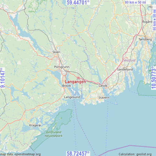
Langangen GPS coordinates[2]
59° 5' 15.684" North, 9° 48' 16.56" East
| Map corner | latitude | longitude |
|---|---|---|
| Upper-left | 59.44701°, | 9.10147° |
| Center: | 59.08769°, | 9.8046° |
| Lower-right: | 58.72457°, | 10.50773° |
| Map W x H: | 80.3×80.3 km | = 49.9×49.9mi |
| max Lat: | 71.04137° ⇑88.9% North |
| Langangen: | 59.08769° |
| min Lat: | ⇓11.1% South 58.0274° |
| min Long | Langangen | max Long |
| 4.71485° | 9.8046° | 31.11066° |
| W 46.8%⇐ | ⇒53.2% E |
Elevation
Elevation of Langangen is 33 m = 108 ft, and this is 71.2 m = 234 ft below average elevation for this country.
| Max E: |
897 m = 2943 ft | 55.9% |
| Avg. | 104.2 m = 342 ft | |
| Langangen | 33 m = 108 ft | |
Min E: |
1 m = 3 ft | 44.1% |
See also: Norway elevation on elevation.city.
Geographical zone
Langangen is located in North temperate zone (between Tropic of Cancer and the Arctic Circle). Distance of this North polar circle is 831.2 km =516.5 mi to North.| Distance of | km | miles | from Langangen |
|---|---|---|---|
| North Pole | 3437.1 | 2135.7 | to North |
| Arctic Circle | 831.2 | 516.5 | to North |
| Tropic Cancer | 3964 | 2463.1 | to South |
| Equator | 6569.9 | 4082.3 | to South |


Nearby cities:
15 places around Langangen: (largest is in red/bold)
• Andebu
32.2 km =20 mi,  41°
41°
• Herre
14 km =8.7 mi,  277°
277°
• Kil
36.2 km =22.5 mi,  232°
232°
• Kragerø
33 km =20.5 mi,  222°
222°
• Kvelde
14.9 km =9.3 mi, 38°
• Langesund
10.2 km =6.3 mi,  198°
198°
• Larvik
13.7 km =8.5 mi,  106°
106°
• Melsomvik
33.9 km =21.1 mi,  63°
63°
• Porsgrunn
10.3 km =6.4 mi,  304°
304°
• Sandefjord
24 km =14.9 mi,  78°
78°
• Siljan
23 km =14.3 mi,  346°
346°
• Skien
17.6 km =10.9 mi,  320°
320°
• Stavern
16.3 km =10.1 mi,  126°
126°
• Stokke
32 km =19.9 mi, 62°
• Tjøme
33.7 km =20.9 mi,  85°
85°
Sources, notices
• [Note1] Compared only with cities in Norway existing in our database
• [Src1] Map data: © OpenStreetMap contributors (CC-BY-SA)
• [Src2] Other city data from geonames.org with taken over terms of usage.
• [Src3] Geographical zone / Annual Mean Temperature by Robert A. Rohde @ Wikipedia
