Våge geodata
Våge (Hordaland) is a populated place; located in Norway in Europe/Oslo (GMT+2) time zone. With population of 513 people, there are 455 cities with bigger population in this country. Compared to other cities in Norway, 63.6% of cities are located further ↑North; 89.7% of cities are located further →East and 100% of cities have higher elevation than Våge. Note1


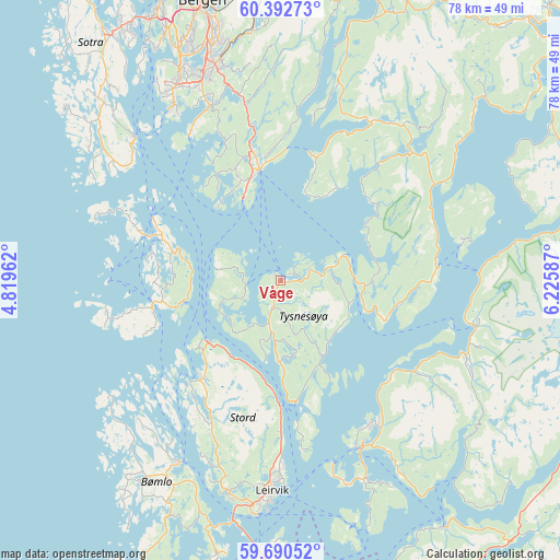
Våge GPS coordinates[2]
60° 2' 36.564" North, 5° 31' 21.864" East
| Map corner | latitude | longitude |
|---|---|---|
| Upper-left | 60.39273°, | 4.81962° |
| Center: | 60.04349°, | 5.52274° |
| Lower-right: | 59.69052°, | 6.22587° |
| Map W x H: | 78.1×78.1 km | = 48.5×48.5mi |
| max Lat: | 71.04137° ⇑63.6% North |
| Våge: | 60.04349° |
| min Lat: | ⇓36.4% South 58.0274° |
| min Long | Våge | max Long |
| 4.71485° | 5.52274° | 31.11066° |
| W 10.3%⇐ | ⇒89.7% E |
Elevation
Elevation of Våge is 1 m = 3 ft, and this is 103.2 m = 339 ft below average elevation for this country.
| Max E: |
897 m = 2943 ft | 100% |
| Avg. | 104.2 m = 342 ft | |
| Våge | 1 m = 3 ft | |
Min E: |
1 m = 3 ft | 0% |
See also: Norway elevation on elevation.city.
Geographical zone
Våge is located in North temperate zone (between Tropic of Cancer and the Arctic Circle). Distance of this North polar circle is 725 km =450.5 mi to North.| Distance of | km | miles | from Våge |
|---|---|---|---|
| North Pole | 3330.9 | 2069.7 | to North |
| Arctic Circle | 725 | 450.5 | to North |
| Tropic Cancer | 4070.3 | 2529.2 | to South |
| Equator | 6676.2 | 4148.4 | to South |


Nearby cities:
15 places around Våge: (largest is in red/bold)
• Eikelandsosen
25.2 km =15.7 mi,  29°
29°
• Fitjar
18.1 km =11.2 mi,  219°
219°
• Hagavik
16.7 km =10.4 mi,  336°
336°
• Klokkarvik
28.8 km =17.9 mi,  314°
314°
• Leirvik
29.3 km =18.2 mi,  182°
182°
• Osøyro
15.9 km =9.9 mi,  348°
348°
• Rosendal
27.9 km =17.3 mi,  103°
103°
• Rubbestadneset
29 km =18 mi,  209°
209°
• Sagvåg
30.1 km =18.7 mi,  194°
194°
• Storebø
17.4 km =10.8 mi,  289°
289°
• Syfteland
22 km =13.7 mi, 349°
• Sæbøvik
29.6 km =18.4 mi,  159°
159°
• Søvik
20.6 km =12.8 mi, 338°
• Uggdal
4.4 km =2.7 mi, 175°
• Uskedalen
22.6 km =14 mi,  122°
122°
Sources, notices
• [Note1] Compared only with cities in Norway existing in our database
• [Src1] Map data: © OpenStreetMap contributors (CC-BY-SA)
• [Src2] Other city data from geonames.org with taken over terms of usage.
• [Src3] Geographical zone / Annual Mean Temperature by Robert A. Rohde @ Wikipedia
