Fitjar geodata
Fitjar (Hordaland) is a seat of a second-order administrative division; located in Norway in Europe/Oslo (GMT+2) time zone. With population of 1,280 people, there are 259 cities with bigger population in this country. Compared to other cities in Norway, 67.2% of cities are located further ↑North; 93.5% of cities are located further →East and 89.4% of cities have higher elevation than Fitjar. Note1


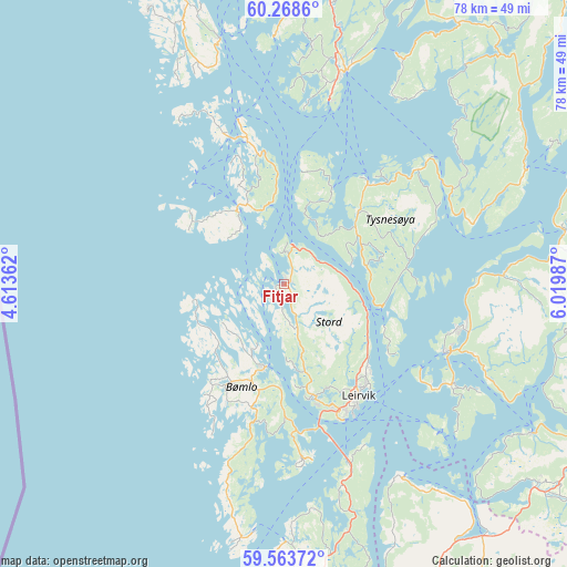
Fitjar GPS coordinates[2]
59° 55' 4.908" North, 5° 19' 0.264" East
| Map corner | latitude | longitude |
|---|---|---|
| Upper-left | 60.2686°, | 4.61362° |
| Center: | 59.91803°, | 5.31674° |
| Lower-right: | 59.56372°, | 6.01987° |
| Map W x H: | 78.4×78.4 km | = 48.7×48.7mi |
| max Lat: | 71.04137° ⇑67.2% North |
| Fitjar: | 59.91803° |
| min Lat: | ⇓32.8% South 58.0274° |
| min Long | Fitjar | max Long |
| 4.71485° | 5.31674° | 31.11066° |
| W 6.5%⇐ | ⇒93.5% E |
Elevation
Elevation of Fitjar is 4 m = 13 ft, and this is 100.2 m = 329 ft below average elevation for this country.
| Max E: |
897 m = 2943 ft | 89.4% |
| Avg. | 104.2 m = 342 ft | |
| Fitjar | 4 m = 13 ft | |
Min E: |
1 m = 3 ft | 10.6% |
See also: Norway elevation on elevation.city.
Geographical zone
Fitjar is located in North temperate zone (between Tropic of Cancer and the Arctic Circle). Distance of this North polar circle is 738.9 km =459.1 mi to North.| Distance of | km | miles | from Fitjar |
|---|---|---|---|
| North Pole | 3344.8 | 2078.4 | to North |
| Arctic Circle | 738.9 | 459.1 | to North |
| Tropic Cancer | 4056.3 | 2520.5 | to South |
| Equator | 6662.3 | 4139.8 | to South |


Nearby cities:
15 places around Fitjar: (largest is in red/bold)
• Hagavik
29.6 km =18.4 mi,  9°
9°
• Holme
30.9 km =19.2 mi,  196°
196°
• Leirvik
18.5 km =11.5 mi,  146°
146°
• Mosterhamn
24.6 km =15.3 mi,  170°
170°
• Osøyro
30.7 km =19.1 mi,  15°
15°
• Rubbestadneset
11.7 km =7.3 mi,  193°
193°
• Sagvåg
15.7 km =9.8 mi,  164°
164°
• Storebø
20.3 km =12.6 mi,  345°
345°
• Svortland
16.1 km =10 mi,  210°
210°
• Sæbøvik
25.9 km =16.1 mi,  122°
122°
• Søvik
33.4 km =20.8 mi, 6°
• Uggdal
15.2 km =9.4 mi,  50°
50°
• Uskedalen
30.5 km =19 mi,  86°
86°
• Valvatna
17.7 km =11 mi, 161°
• Våge
18.1 km =11.2 mi,  39°
39°
Sources, notices
• [Note1] Compared only with cities in Norway existing in our database
• [Src1] Map data: © OpenStreetMap contributors (CC-BY-SA)
• [Src2] Other city data from geonames.org with taken over terms of usage.
• [Src3] Geographical zone / Annual Mean Temperature by Robert A. Rohde @ Wikipedia
