Mo geodata
Mo (Hordaland) is a seat of a second-order administrative division; located in Norway in Europe/Oslo (GMT+2) time zone. In our database, there are 488 cities with bigger population. Compared to other cities in Norway, 53.3% of cities are located further ↓South; 85.6% of cities are located further →East and 91.6% of cities have lower elevation than Mo. Note1


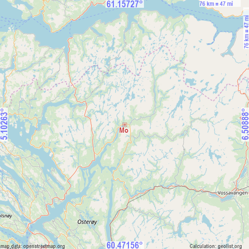
Mo GPS coordinates[2]
60° 48' 58.5" North, 5° 48' 20.7" East
| Map corner | latitude | longitude |
|---|---|---|
| Upper-left | 61.15727°, | 5.10263° |
| Center: | 60.81625°, | 5.80575° |
| Lower-right: | 60.47156°, | 6.50888° |
| Map W x H: | 76.2×76.2 km | = 47.3×47.3mi |
| max Lat: | 71.04137° ⇑46.7% North |
| Mo: | 60.81625° |
| min Lat: | ⇓53.3% South 58.0274° |
| min Long | Mo | max Long |
| 4.71485° | 5.80575° | 31.11066° |
| W 14.4%⇐ | ⇒85.6% E |
Elevation
Elevation of Mo is 320 m = 1050 ft, and this is 215.8 m = 708 ft above average elevation for this country.
| Max E: |
897 m = 2943 ft | 8.4% |
| Mo | 320 m 1050 ft | |
| Avg. | 104.2 m = 342 ft | |
Min E: |
1 m = 3 ft | 91.6% |
See also: Norway elevation on elevation.city.
Geographical zone
Mo is located in North temperate zone (between Tropic of Cancer and the Arctic Circle). Distance of this North polar circle is 639 km =397.1 mi to North.| Distance of | km | miles | from Mo |
|---|---|---|---|
| North Pole | 3244.9 | 2016.3 | to North |
| Arctic Circle | 639 | 397.1 | to North |
| Tropic Cancer | 4156.2 | 2582.5 | to South |
| Equator | 6762.1 | 4201.8 | to South |


Nearby cities:
15 places around Mo: (largest is in red/bold)
• Austrheim
47.6 km =29.6 mi,  264°
264°
• Dale
25.6 km =15.9 mi,  178°
178°
• Eivindvik
43.6 km =27.1 mi,  294°
294°
• Frekhaug
45.6 km =28.3 mi,  222°
222°
• Hylkje
42 km =26.1 mi, 215°
• Isdalstø
41.2 km =25.6 mi,  225°
225°
• Knarvik
41.5 km =25.8 mi, 223°
• Lindås
36.1 km =22.4 mi, 255°
• Lonevåg
36.5 km =22.7 mi,  207°
207°
• Manger
45.9 km =28.5 mi,  244°
244°
• Masfjorden
27.3 km =17 mi,  265°
265°
• Stanghelle
29.6 km =18.4 mi,  187°
187°
• Vaksdal
37.9 km =23.5 mi, 185°
• Voss
39.1 km =24.3 mi,  122°
122°
• Ytre Arna
44.4 km =27.6 mi, 207°
Sources, notices
• [Note1] Compared only with cities in Norway existing in our database
• [Src1] Map data: © OpenStreetMap contributors (CC-BY-SA)
• [Src2] Other city data from geonames.org with taken over terms of usage.
• [Src3] Geographical zone / Annual Mean Temperature by Robert A. Rohde @ Wikipedia
