Lindås geodata
Lindås (Hordaland) is a populated place; located in Norway in Europe/Oslo (GMT+2) time zone. With population of 1,087 people, there are 296 cities with bigger population in this country. Compared to other cities in Norway, 51.9% of cities are located further ↓South; 97.2% of cities are located further →East and 54.9% of cities have lower elevation than Lindås. Note1


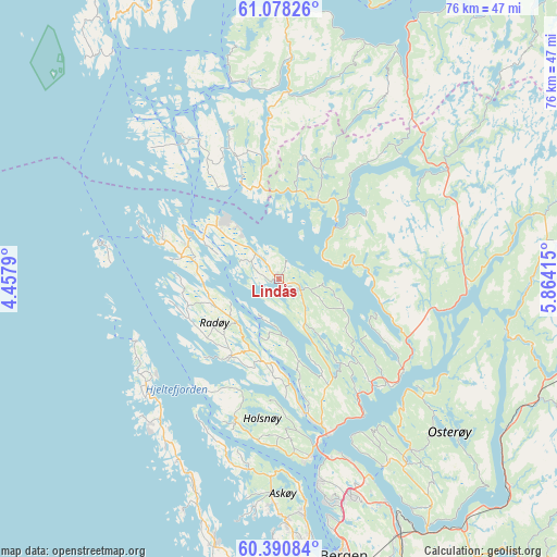
Lindås GPS coordinates[2]
60° 44' 11.004" North, 5° 9' 39.672" East
| Map corner | latitude | longitude |
|---|---|---|
| Upper-left | 61.07826°, | 4.4579° |
| Center: | 60.73639°, | 5.16102° |
| Lower-right: | 60.39084°, | 5.86415° |
| Map W x H: | 76.4×76.4 km | = 47.5×47.5mi |
| max Lat: | 71.04137° ⇑48.1% North |
| Lindås: | 60.73639° |
| min Lat: | ⇓51.9% South 58.0274° |
| min Long | Lindås | max Long |
| 4.71485° | 5.16102° | 31.11066° |
| W 2.8%⇐ | ⇒97.2% E |
Elevation
Elevation of Lindås is 60 m = 197 ft, and this is 44.2 m = 145 ft below average elevation for this country.
| Max E: |
897 m = 2943 ft | 45.1% |
| Avg. | 104.2 m = 342 ft | |
| Lindås | 60 m = 197 ft | |
Min E: |
1 m = 3 ft | 54.9% |
See also: Norway elevation on elevation.city.
Geographical zone
Lindås is located in North temperate zone (between Tropic of Cancer and the Arctic Circle). Distance of this North polar circle is 647.9 km =402.6 mi to North.| Distance of | km | miles | from Lindås |
|---|---|---|---|
| North Pole | 3253.8 | 2021.8 | to North |
| Arctic Circle | 647.9 | 402.6 | to North |
| Tropic Cancer | 4147.3 | 2577 | to South |
| Equator | 6753.3 | 4196.3 | to South |


Nearby cities:
15 places around Lindås: (largest is in red/bold)
• Austrheim
13.2 km =8.2 mi,  290°
290°
• Eivindvik
27.6 km =17.1 mi,  350°
350°
• Fedje
24.7 km =15.3 mi,  281°
281°
• Frekhaug
25.2 km =15.7 mi,  169°
169°
• Hylkje
27.3 km =17 mi,  157°
157°
• Isdalstø
21 km =13 mi, 163°
• Knarvik
22.2 km =13.8 mi, 162°
• Lonevåg
29.7 km =18.5 mi,  142°
142°
• Manger
12.4 km =7.7 mi,  211°
211°
• Masfjorden
10.4 km =6.5 mi,  48°
48°
• Mo
36.1 km =22.4 mi,  75°
75°
• Sollsvika
35 km =21.7 mi,  197°
197°
• Tjeldstø
23.2 km =14.4 mi,  227°
227°
• Ytre Arna
33.9 km =21.1 mi,  154°
154°
• Årås
13.2 km =8.2 mi, 290°
Sources, notices
• [Note1] Compared only with cities in Norway existing in our database
• [Src1] Map data: © OpenStreetMap contributors (CC-BY-SA)
• [Src2] Other city data from geonames.org with taken over terms of usage.
• [Src3] Geographical zone / Annual Mean Temperature by Robert A. Rohde @ Wikipedia
