Manger geodata
Manger (Hordaland) is a seat of a second-order administrative division; located in Norway in Europe/Oslo (GMT+2) time zone. With population of 814 people, there are 354 cities with bigger population in this country. Compared to other cities in Norway, 50.3% of cities are located further ↓South; 98.6% of cities are located further →East and 69% of cities have higher elevation than Manger. Note1


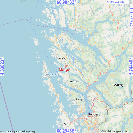
Manger GPS coordinates[2]
60° 38' 29.22" North, 5° 2' 28.896" East
| Map corner | latitude | longitude |
|---|---|---|
| Upper-left | 60.98433°, | 4.33823° |
| Center: | 60.64145°, | 5.04136° |
| Lower-right: | 60.29488°, | 5.74448° |
| Map W x H: | 76.7×76.7 km | = 47.7×47.7mi |
| max Lat: | 71.04137° ⇑49.7% North |
| Manger: | 60.64145° |
| min Lat: | ⇓50.3% South 58.0274° |
| min Long | Manger | max Long |
| 4.71485° | 5.04136° | 31.11066° |
| W 1.4%⇐ | ⇒98.6% E |
Elevation
Elevation of Manger is 20 m = 66 ft, and this is 84.2 m = 276 ft below average elevation for this country.
| Max E: |
897 m = 2943 ft | 69% |
| Avg. | 104.2 m = 342 ft | |
| Manger | 20 m = 66 ft | |
Min E: |
1 m = 3 ft | 31% |
See also: Norway elevation on elevation.city.
Geographical zone
Manger is located in North temperate zone (between Tropic of Cancer and the Arctic Circle). Distance of this North polar circle is 658.5 km =409.2 mi to North.| Distance of | km | miles | from Manger |
|---|---|---|---|
| North Pole | 3264.4 | 2028.4 | to North |
| Arctic Circle | 658.5 | 409.2 | to North |
| Tropic Cancer | 4136.8 | 2570.5 | to South |
| Equator | 6742.7 | 4189.7 | to South |


Nearby cities:
15 places around Manger: (largest is in red/bold)
• Askøy
27.9 km =17.3 mi,  163°
163°
• Austrheim
16.2 km =10.1 mi,  338°
338°
• Fedje
23.4 km =14.5 mi,  310°
310°
• Frekhaug
18 km =11.2 mi,  142°
142°
• Hylkje
22.5 km =14 mi,  130°
130°
• Isdalstø
15.7 km =9.8 mi, 127°
• Kleppestø
27.8 km =17.3 mi, 158°
• Knarvik
16.9 km =10.5 mi, 129°
• Lindås
12.4 km =7.7 mi,  31°
31°
• Lonevåg
28 km =17.4 mi,  117°
117°
• Masfjorden
22.6 km =14 mi,  39°
39°
• Sollsvika
23.2 km =14.4 mi,  190°
190°
• Tjeldstø
11.9 km =7.4 mi,  244°
244°
• Ågotnes
26.5 km =16.5 mi,  182°
182°
• Årås
16.2 km =10.1 mi, 338°
Sources, notices
• [Note1] Compared only with cities in Norway existing in our database
• [Src1] Map data: © OpenStreetMap contributors (CC-BY-SA)
• [Src2] Other city data from geonames.org with taken over terms of usage.
• [Src3] Geographical zone / Annual Mean Temperature by Robert A. Rohde @ Wikipedia
