Knarvik geodata
Knarvik (Hordaland) is a populated place; located in Norway in Europe/Oslo (GMT+2) time zone. With population of 4,265 people, there are 104 cities with bigger population in this country. Compared to other cities in Norway, 51.7% of cities are located further ↑North; 94.6% of cities are located further →East and 53.8% of cities have higher elevation than Knarvik. Note1


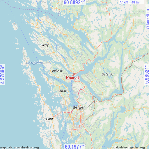
Knarvik GPS coordinates[2]
60° 32' 43.08" North, 5° 16' 55.488" East
| Map corner | latitude | longitude |
|---|---|---|
| Upper-left | 60.88921°, | 4.57896° |
| Center: | 60.5453°, | 5.28208° |
| Lower-right: | 60.1977°, | 5.98521° |
| Map W x H: | 76.9×76.9 km | = 47.8×47.8mi |
| max Lat: | 71.04137° ⇑51.7% North |
| Knarvik: | 60.5453° |
| min Lat: | ⇓48.3% South 58.0274° |
| min Long | Knarvik | max Long |
| 4.71485° | 5.28208° | 31.11066° |
| W 5.4%⇐ | ⇒94.6% E |
Elevation
Elevation of Knarvik is 36 m = 118 ft, and this is 68.2 m = 224 ft below average elevation for this country.
| Max E: |
897 m = 2943 ft | 53.8% |
| Avg. | 104.2 m = 342 ft | |
| Knarvik | 36 m = 118 ft | |
Min E: |
1 m = 3 ft | 46.2% |
See also: Norway elevation on elevation.city.
Geographical zone
Knarvik is located in North temperate zone (between Tropic of Cancer and the Arctic Circle). Distance of this North polar circle is 669.2 km =415.8 mi to North.| Distance of | km | miles | from Knarvik |
|---|---|---|---|
| North Pole | 3275.1 | 2035.1 | to North |
| Arctic Circle | 669.2 | 415.8 | to North |
| Tropic Cancer | 4126.1 | 2563.8 | to South |
| Equator | 6732 | 4183.1 | to South |


Nearby cities:
15 places around Knarvik: (largest is in red/bold)
• Askøy
17 km =10.6 mi,  198°
198°
• Bergen
17.1 km =10.6 mi,  172°
172°
• Espeland
20.7 km =12.9 mi,  150°
150°
• Frekhaug
4.2 km =2.6 mi,  211°
211°
• Hylkje
5.6 km =3.5 mi,  134°
134°
• Indre Arna
17.6 km =10.9 mi,  143°
143°
• Isdalstø
1.3 km =0.8 mi,  327°
327°
• Kleppestø
15.5 km =9.6 mi,  191°
191°
• Lindås
22.2 km =13.8 mi,  342°
342°
• Lonevåg
11.9 km =7.4 mi,  100°
100°
• Manger
16.9 km =10.5 mi,  309°
309°
• Sollsvika
21.1 km =13.1 mi,  234°
234°
• Straume
22.3 km =13.9 mi, 203°
• Ytre Arna
12.4 km =7.7 mi, 138°
• Ågotnes
21.4 km =13.3 mi,  222°
222°
Sources, notices
• [Note1] Compared only with cities in Norway existing in our database
• [Src1] Map data: © OpenStreetMap contributors (CC-BY-SA)
• [Src2] Other city data from geonames.org with taken over terms of usage.
• [Src3] Geographical zone / Annual Mean Temperature by Robert A. Rohde @ Wikipedia
