Isdalstø geodata
Isdalstø (Hordaland) is a seat of a second-order administrative division; located in Norway in Europe/Oslo (GMT+2) time zone. In our database, there are 488 cities with bigger population. Compared to other cities in Norway, 51.3% of cities are located further ↑North; 94.8% of cities are located further →East and 54.9% of cities have lower elevation than Isdalstø. Note1


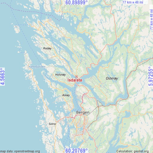
Isdalstø GPS coordinates[2]
60° 33' 18.684" North, 5° 16' 9.912" East
| Map corner | latitude | longitude |
|---|---|---|
| Upper-left | 60.89899°, | 4.5663° |
| Center: | 60.55519°, | 5.26942° |
| Lower-right: | 60.20769°, | 5.97255° |
| Map W x H: | 76.9×76.9 km | = 47.8×47.8mi |
| max Lat: | 71.04137° ⇑51.3% North |
| Isdalstø: | 60.55519° |
| min Lat: | ⇓48.7% South 58.0274° |
| min Long | Isdalstø | max Long |
| 4.71485° | 5.26942° | 31.11066° |
| W 5.2%⇐ | ⇒94.8% E |
Elevation
Elevation of Isdalstø is 60 m = 197 ft, and this is 44.2 m = 145 ft below average elevation for this country.
| Max E: |
897 m = 2943 ft | 45.1% |
| Avg. | 104.2 m = 342 ft | |
| Isdalstø | 60 m = 197 ft | |
Min E: |
1 m = 3 ft | 54.9% |
See also: Norway elevation on elevation.city.
Geographical zone
Isdalstø is located in North temperate zone (between Tropic of Cancer and the Arctic Circle). Distance of this North polar circle is 668.1 km =415.1 mi to North.| Distance of | km | miles | from Isdalstø |
|---|---|---|---|
| North Pole | 3274 | 2034.4 | to North |
| Arctic Circle | 668.1 | 415.1 | to North |
| Tropic Cancer | 4127.2 | 2564.5 | to South |
| Equator | 6733.1 | 4183.8 | to South |


Nearby cities:
15 places around Isdalstø: (largest is in red/bold)
• Askøy
17.9 km =11.1 mi,  195°
195°
• Bergen
18.3 km =11.4 mi,  170°
170°
• Espeland
22 km =13.7 mi,  150°
150°
• Frekhaug
4.9 km =3 mi, 197°
• Hylkje
6.8 km =4.2 mi,  137°
137°
• Indre Arna
18.9 km =11.7 mi, 144°
• Kleppestø
16.5 km =10.3 mi,  187°
187°
• Knappskog
22.8 km =14.2 mi,  210°
210°
• Knarvik
1.3 km =0.8 mi, 147°
• Lindås
21 km =13 mi,  343°
343°
• Lonevåg
12.8 km =8 mi,  104°
104°
• Manger
15.7 km =9.8 mi,  307°
307°
• Sollsvika
21.2 km =13.2 mi,  231°
231°
• Ytre Arna
13.7 km =8.5 mi, 139°
• Ågotnes
21.8 km =13.5 mi,  219°
219°
Sources, notices
• [Note1] Compared only with cities in Norway existing in our database
• [Src1] Map data: © OpenStreetMap contributors (CC-BY-SA)
• [Src2] Other city data from geonames.org with taken over terms of usage.
• [Src3] Geographical zone / Annual Mean Temperature by Robert A. Rohde @ Wikipedia
