Elnesvågen geodata
Elnesvågen (Møre og Romsdal) is a seat of a second-order administrative division; located in Norway in Europe/Oslo (GMT+2) time zone. With population of 2,362 people, there are 168 cities with bigger population in this country. Compared to other cities in Norway, 71.8% of cities are located further ↓South; 72.5% of cities are located further →East and 58.2% of cities have higher elevation than Elnesvågen. Note1


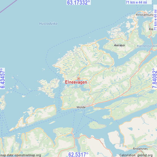
Elnesvågen GPS coordinates[2]
62° 51' 15.336" North, 7° 8' 15.684" East
| Map corner | latitude | longitude |
|---|---|---|
| Upper-left | 63.17332°, | 6.43457° |
| Center: | 62.85426°, | 7.13769° |
| Lower-right: | 62.5317°, | 7.84082° |
| Map W x H: | 71.3×71.3 km | = 44.3×44.3mi |
| max Lat: | 71.04137° ⇑28.2% North |
| Elnesvågen: | 62.85426° |
| min Lat: | ⇓71.8% South 58.0274° |
| min Long | Elnesvågen | max Long |
| 4.71485° | 7.13769° | 31.11066° |
| W 27.5%⇐ | ⇒72.5% E |
Elevation
Elevation of Elnesvågen is 30 m = 98 ft, and this is 74.2 m = 243 ft below average elevation for this country.
| Max E: |
897 m = 2943 ft | 58.2% |
| Avg. | 104.2 m = 342 ft | |
| Elnesvågen | 30 m = 98 ft | |
Min E: |
1 m = 3 ft | 41.8% |
See also: Norway elevation on elevation.city.
Geographical zone
Elnesvågen is located in North temperate zone (between Tropic of Cancer and the Arctic Circle). Distance of this North polar circle is 412.4 km =256.3 mi to North.| Distance of | km | miles | from Elnesvågen |
|---|---|---|---|
| North Pole | 3018.3 | 1875.5 | to North |
| Arctic Circle | 412.4 | 256.3 | to North |
| Tropic Cancer | 4382.8 | 2723.3 | to South |
| Equator | 6988.7 | 4342.6 | to South |


Nearby cities:
15 places around Elnesvågen: (largest is in red/bold)
• Aukra
14.4 km =8.9 mi,  236°
236°
• Batnfjordsøra
27.5 km =17.1 mi,  80°
80°
• Bruhagen
33.4 km =20.8 mi,  48°
48°
• Bud
12.8 km =8 mi,  297°
297°
• Eide
17.2 km =10.7 mi,  65°
65°
• Falkhytta
13.8 km =8.6 mi,  246°
246°
• Hjelset
19.8 km =12.3 mi,  114°
114°
• Kristiansund
41.2 km =25.6 mi, 46°
• Midsund
31 km =19.3 mi,  229°
229°
• Molde
13 km =8.1 mi,  175°
175°
• Steinshamn
34.8 km =21.6 mi,  256°
256°
• Tomra
32.1 km =19.9 mi,  199°
199°
• Vatne
42.3 km =26.3 mi,  218°
218°
• Vestnes
25.6 km =15.9 mi,  185°
185°
• Åndalsnes
42.4 km =26.3 mi,  138°
138°
Sources, notices
• [Note1] Compared only with cities in Norway existing in our database
• [Src1] Map data: © OpenStreetMap contributors (CC-BY-SA)
• [Src2] Other city data from geonames.org with taken over terms of usage.
• [Src3] Geographical zone / Annual Mean Temperature by Robert A. Rohde @ Wikipedia
