Straumen geodata
Straumen (Trøndelag) is a seat of a second-order administrative division; located in Norway in Europe/Oslo (GMT+2) time zone. With population of 1,147 people, there are 283 cities with bigger population in this country. Compared to other cities in Norway, 79.3% of cities are located further ↓South; 74.1% of cities are located further ←West and 100% of cities have higher elevation than Straumen. Note1


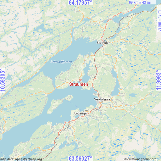
Straumen GPS coordinates[2]
63° 52' 17.868" North, 11° 17' 46.212" East
| Map corner | latitude | longitude |
|---|---|---|
| Upper-left | 64.17957°, | 10.59305° |
| Center: | 63.87163°, | 11.29617° |
| Lower-right: | 63.56027°, | 11.9993° |
| Map W x H: | 68.9×68.9 km | = 42.8×42.8mi |
| max Lat: | 71.04137° ⇑20.7% North |
| Straumen: | 63.87163° |
| min Lat: | ⇓79.3% South 58.0274° |
| min Long | Straumen | max Long |
| 4.71485° | 11.29617° | 31.11066° |
| W 74.1%⇐ | ⇒25.9% E |
Elevation
Elevation of Straumen is 1 m = 3 ft, and this is 103.2 m = 339 ft below average elevation for this country.
| Max E: |
897 m = 2943 ft | 100% |
| Avg. | 104.2 m = 342 ft | |
| Straumen | 1 m = 3 ft | |
Min E: |
1 m = 3 ft | 0% |
See also: Norway elevation on elevation.city.
Geographical zone
Straumen is located in North temperate zone (between Tropic of Cancer and the Arctic Circle). Distance of this North polar circle is 299.3 km =186 mi to North.| Distance of | km | miles | from Straumen |
|---|---|---|---|
| North Pole | 2905.2 | 1805.2 | to North |
| Arctic Circle | 299.3 | 186 | to North |
| Tropic Cancer | 4495.9 | 2793.6 | to South |
| Equator | 7101.9 | 4412.9 | to South |


Nearby cities:
15 places around Straumen: (largest is in red/bold)
• Frosta
41.6 km =25.8 mi,  220°
220°
• Hegra
46.2 km =28.7 mi,  191°
191°
• Hell
51.2 km =31.8 mi,  202°
202°
• Leksvik
39.8 km =24.7 mi,  236°
236°
• Levanger
13.9 km =8.6 mi,  179°
179°
• Malm
22.9 km =14.2 mi,  351°
351°
• Namdalseid
39.1 km =24.3 mi, 354°
• Skogn
19.3 km =12 mi, 195°
• Sparbu
8.5 km =5.3 mi,  51°
51°
• Steinkjer
18.7 km =11.6 mi,  31°
31°
• Stjørdal
48.6 km =30.2 mi, 202°
• Stjørdalshalsen
48.4 km =30.1 mi, 202°
• Verdal
12.6 km =7.8 mi,  133°
133°
• Å i Åfjord
53.3 km =33.1 mi,  280°
280°
• Årnes
53.3 km =33.1 mi, 280°
Sources, notices
• [Note1] Compared only with cities in Norway existing in our database
• [Src1] Map data: © OpenStreetMap contributors (CC-BY-SA)
• [Src2] Other city data from geonames.org with taken over terms of usage.
• [Src3] Geographical zone / Annual Mean Temperature by Robert A. Rohde @ Wikipedia
