Verdal geodata
Verdal (Trøndelag) is a seat of a second-order administrative division; located in Norway in Europe/Oslo (GMT+2) time zone. With population of 7,154 people, there are 63 cities with bigger population in this country. Compared to other cities in Norway, 79.1% of cities are located further ↓South; 77.7% of cities are located further ←West and 79% of cities have higher elevation than Verdal. Note1


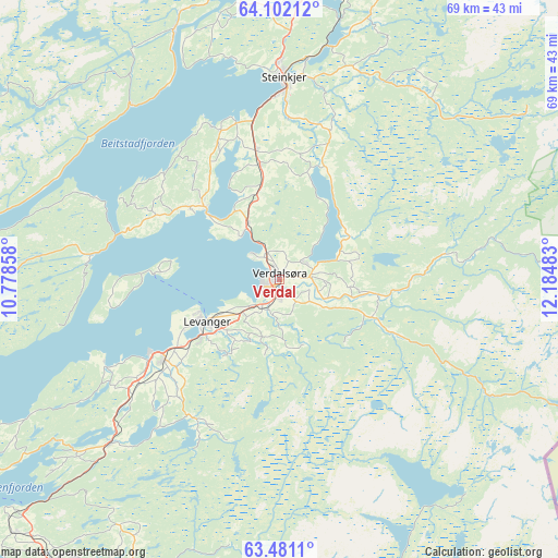
Verdal GPS coordinates[2]
63° 47' 35.952" North, 11° 28' 54.12" East
| Map corner | latitude | longitude |
|---|---|---|
| Upper-left | 64.10212°, | 10.77858° |
| Center: | 63.79332°, | 11.4817° |
| Lower-right: | 63.4811°, | 12.18483° |
| Map W x H: | 69.1×69 km | = 42.9×42.9mi |
| max Lat: | 71.04137° ⇑20.9% North |
| Verdal: | 63.79332° |
| min Lat: | ⇓79.1% South 58.0274° |
| min Long | Verdal | max Long |
| 4.71485° | 11.4817° | 31.11066° |
| W 77.7%⇐ | ⇒22.3% E |
Elevation
Elevation of Verdal is 11 m = 36 ft, and this is 93.2 m = 306 ft below average elevation for this country.
| Max E: |
897 m = 2943 ft | 79% |
| Avg. | 104.2 m = 342 ft | |
| Verdal | 11 m = 36 ft | |
Min E: |
1 m = 3 ft | 21% |
See also: Norway elevation on elevation.city.
Geographical zone
Verdal is located in North temperate zone (between Tropic of Cancer and the Arctic Circle). Distance of this North polar circle is 308 km =191.4 mi to North.| Distance of | km | miles | from Verdal |
|---|---|---|---|
| North Pole | 2913.9 | 1810.6 | to North |
| Arctic Circle | 308 | 191.4 | to North |
| Tropic Cancer | 4487.2 | 2788.2 | to South |
| Equator | 7093.2 | 4407.5 | to South |


Nearby cities:
15 places around Verdal: (largest is in red/bold)
• Frosta
42.9 km =26.7 mi,  238°
238°
• Hegra
40.9 km =25.4 mi,  206°
206°
• Hell
48.1 km =29.9 mi,  216°
216°
• Hommelvik
54.4 km =33.8 mi, 218°
• Leksvik
44.3 km =27.5 mi,  252°
252°
• Levanger
10.4 km =6.5 mi, 239°
• Malm
33.8 km =21 mi,  338°
338°
• Meråker
44.1 km =27.4 mi,  162°
162°
• Namdalseid
49.3 km =30.6 mi,  345°
345°
• Skogn
17.4 km =10.8 mi,  234°
234°
• Sparbu
14.2 km =8.8 mi, 350°
• Steinkjer
24.6 km =15.3 mi,  1°
1°
• Stjørdal
45.6 km =28.3 mi, 217°
• Stjørdalshalsen
45.4 km =28.2 mi, 217°
• Straumen
12.6 km =7.8 mi,  313°
313°
Sources, notices
• [Note1] Compared only with cities in Norway existing in our database
• [Src1] Map data: © OpenStreetMap contributors (CC-BY-SA)
• [Src2] Other city data from geonames.org with taken over terms of usage.
• [Src3] Geographical zone / Annual Mean Temperature by Robert A. Rohde @ Wikipedia
