Sparbu geodata
Sparbu (Trøndelag) is a populated place; located in Norway in Europe/Oslo (GMT+2) time zone. With population of 635 people, there are 405 cities with bigger population in this country. Compared to other cities in Norway, 79.4% of cities are located further ↓South; 76.7% of cities are located further ←West and 54.9% of cities have lower elevation than Sparbu. Note1


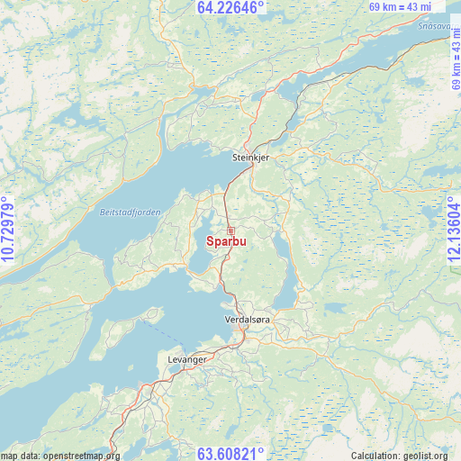
Sparbu GPS coordinates[2]
63° 55' 8.544" North, 11° 25' 58.476" East
| Map corner | latitude | longitude |
|---|---|---|
| Upper-left | 64.22646°, | 10.72979° |
| Center: | 63.91904°, | 11.43291° |
| Lower-right: | 63.60821°, | 12.13604° |
| Map W x H: | 68.7×68.7 km | = 42.7×42.7mi |
| max Lat: | 71.04137° ⇑20.6% North |
| Sparbu: | 63.91904° |
| min Lat: | ⇓79.4% South 58.0274° |
| min Long | Sparbu | max Long |
| 4.71485° | 11.43291° | 31.11066° |
| W 76.7%⇐ | ⇒23.3% E |
Elevation
Elevation of Sparbu is 60 m = 197 ft, and this is 44.2 m = 145 ft below average elevation for this country.
| Max E: |
897 m = 2943 ft | 45.1% |
| Avg. | 104.2 m = 342 ft | |
| Sparbu | 60 m = 197 ft | |
Min E: |
1 m = 3 ft | 54.9% |
See also: Norway elevation on elevation.city.
Geographical zone
Sparbu is located in North temperate zone (between Tropic of Cancer and the Arctic Circle). Distance of this North polar circle is 294 km =182.7 mi to North.| Distance of | km | miles | from Sparbu |
|---|---|---|---|
| North Pole | 2899.9 | 1801.9 | to North |
| Arctic Circle | 294 | 182.7 | to North |
| Tropic Cancer | 4501.2 | 2796.9 | to South |
| Equator | 7107.1 | 4416.1 | to South |


Nearby cities:
15 places around Sparbu: (largest is in red/bold)
• Bangsund
52.7 km =32.7 mi,  358°
358°
• Frosta
50 km =31.1 mi,  222°
222°
• Hegra
53 km =32.9 mi,  197°
197°
• Leksvik
48.3 km =30 mi,  235°
235°
• Levanger
20.3 km =12.6 mi, 198°
• Malm
20.1 km =12.5 mi,  329°
329°
• Meråker
58.2 km =36.2 mi,  164°
164°
• Namdalseid
35.2 km =21.9 mi,  343°
343°
• Skogn
26.7 km =16.6 mi,  206°
206°
• Snåase
58.5 km =36.4 mi,  51°
51°
• Steinkjer
11.1 km =6.9 mi,  15°
15°
• Stjørdal
56.2 km =34.9 mi, 206°
• Stjørdalshalsen
56 km =34.8 mi, 206°
• Straumen
8.5 km =5.3 mi,  231°
231°
• Verdal
14.2 km =8.8 mi,  170°
170°
Sources, notices
• [Note1] Compared only with cities in Norway existing in our database
• [Src1] Map data: © OpenStreetMap contributors (CC-BY-SA)
• [Src2] Other city data from geonames.org with taken over terms of usage.
• [Src3] Geographical zone / Annual Mean Temperature by Robert A. Rohde @ Wikipedia
