Kil geodata
Kil (Telemark) is a populated place; located in Norway in Europe/Oslo (GMT+2) time zone. With population of 901 people, there are 332 cities with bigger population in this country. Compared to other cities in Norway, 91.1% of cities are located further ↑North; 57% of cities are located further →East and 65% of cities have higher elevation than Kil. Note1


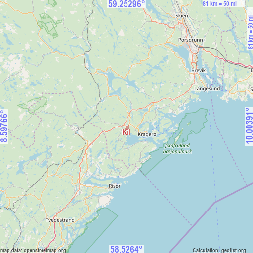
Kil GPS coordinates[2]
58° 53' 29.724" North, 9° 18' 2.808" East
| Map corner | latitude | longitude |
|---|---|---|
| Upper-left | 59.25296°, | 8.59766° |
| Center: | 58.89159°, | 9.30078° |
| Lower-right: | 58.5264°, | 10.00391° |
| Map W x H: | 80.8×80.8 km | = 50.2×50.2mi |
| max Lat: | 71.04137° ⇑91.1% North |
| Kil: | 58.89159° |
| min Lat: | ⇓8.9% South 58.0274° |
| min Long | Kil | max Long |
| 4.71485° | 9.30078° | 31.11066° |
| W 43%⇐ | ⇒57% E |
Elevation
Elevation of Kil is 21 m = 69 ft, and this is 83.2 m = 273 ft below average elevation for this country.
| Max E: |
897 m = 2943 ft | 65% |
| Avg. | 104.2 m = 342 ft | |
| Kil | 21 m = 69 ft | |
Min E: |
1 m = 3 ft | 35% |
See also: Norway elevation on elevation.city.
Geographical zone
Kil is located in North temperate zone (between Tropic of Cancer and the Arctic Circle). Distance of this North polar circle is 853 km =530 mi to North.| Distance of | km | miles | from Kil |
|---|---|---|---|
| North Pole | 3458.9 | 2149.3 | to North |
| Arctic Circle | 853 | 530 | to North |
| Tropic Cancer | 3942.2 | 2449.6 | to South |
| Equator | 6548.1 | 4068.8 | to South |


Nearby cities:
15 places around Kil: (largest is in red/bold)
• Gjerstad
16.3 km =10.1 mi,  265°
265°
• Herre
27.9 km =17.3 mi,  32°
32°
• Kragerø
7 km =4.3 mi,  110°
110°
• Langangen
36.2 km =22.5 mi,  52°
52°
• Langesund
28.4 km =17.6 mi,  64°
64°
• Larvik
45.8 km =28.5 mi,  66°
66°
• Lunde
46.6 km =29 mi,  345°
345°
• Myra
29.8 km =18.5 mi,  237°
237°
• Porsgrunn
34.3 km =21.3 mi,  36°
36°
• Prestestranda
26.8 km =16.7 mi,  328°
328°
• Risør
19.4 km =12.1 mi,  191°
191°
• Skien
39.5 km =24.5 mi, 26°
• Stavern
43.7 km =27.2 mi, 73°
• Tvedestrand
36.8 km =22.9 mi,  215°
215°
• Ulefoss
43.5 km =27 mi,  357°
357°
Sources, notices
• [Note1] Compared only with cities in Norway existing in our database
• [Src1] Map data: © OpenStreetMap contributors (CC-BY-SA)
• [Src2] Other city data from geonames.org with taken over terms of usage.
• [Src3] Geographical zone / Annual Mean Temperature by Robert A. Rohde @ Wikipedia
