Porsgrunn geodata
Porsgrunn (Telemark) is a seat of a second-order administrative division; located in Norway in Europe/Oslo (GMT+2) time zone. With population of 34,377 people, there are 17 cities with bigger population in this country. Compared to other cities in Norway, 87.8% of cities are located further ↑North; 54.6% of cities are located further →East and 82.9% of cities have higher elevation than Porsgrunn. Note1


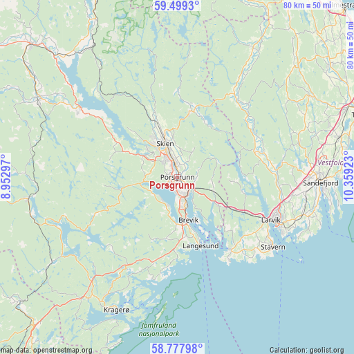
Porsgrunn GPS coordinates[2]
59° 8' 25.944" North, 9° 39' 21.96" East
| Map corner | latitude | longitude |
|---|---|---|
| Upper-left | 59.4993°, | 8.95297° |
| Center: | 59.14054°, | 9.6561° |
| Lower-right: | 58.77798°, | 10.35923° |
| Map W x H: | 80.2×80.2 km | = 49.8×49.8mi |
| max Lat: | 71.04137° ⇑87.8% North |
| Porsgrunn: | 59.14054° |
| min Lat: | ⇓12.2% South 58.0274° |
| min Long | Porsgrunn | max Long |
| 4.71485° | 9.6561° | 31.11066° |
| W 45.4%⇐ | ⇒54.6% E |
Elevation
Elevation of Porsgrunn is 9 m = 30 ft, and this is 95.2 m = 312 ft below average elevation for this country.
| Max E: |
897 m = 2943 ft | 82.9% |
| Avg. | 104.2 m = 342 ft | |
| Porsgrunn | 9 m = 30 ft | |
Min E: |
1 m = 3 ft | 17.1% |
See also: Norway elevation on elevation.city.
Geographical zone
Porsgrunn is located in North temperate zone (between Tropic of Cancer and the Arctic Circle). Distance of this North polar circle is 825.4 km =512.9 mi to North.| Distance of | km | miles | from Porsgrunn |
|---|---|---|---|
| North Pole | 3431.3 | 2132.1 | to North |
| Arctic Circle | 825.4 | 512.9 | to North |
| Tropic Cancer | 3969.9 | 2466.8 | to South |
| Equator | 6575.8 | 4086 | to South |


Nearby cities:
15 places around Porsgrunn: (largest is in red/bold)
• Andebu
34.9 km =21.7 mi,  58°
58°
• Herre
6.8 km =4.2 mi,  232°
232°
• Kil
34.3 km =21.3 mi,  216°
216°
• Kragerø
33.2 km =20.6 mi,  204°
204°
• Kvelde
18.7 km =11.6 mi,  72°
72°
• Langangen
10.3 km =6.4 mi,  124°
124°
• Langesund
16.4 km =10.2 mi,  161°
161°
• Larvik
23.7 km =14.7 mi,  114°
114°
• Lunde
36 km =22.4 mi,  299°
299°
• Prestestranda
34.4 km =21.4 mi,  262°
262°
• Sandefjord
32 km =19.9 mi,  91°
91°
• Siljan
16.7 km =10.4 mi,  10°
10°
• Skien
8.1 km =5 mi,  340°
340°
• Stavern
26.6 km =16.5 mi,  125°
125°
• Ulefoss
27.3 km =17 mi,  305°
305°
Sources, notices
• [Note1] Compared only with cities in Norway existing in our database
• [Src1] Map data: © OpenStreetMap contributors (CC-BY-SA)
• [Src2] Other city data from geonames.org with taken over terms of usage.
• [Src3] Geographical zone / Annual Mean Temperature by Robert A. Rohde @ Wikipedia
