Herre geodata
Herre (Telemark) is a populated place; located in Norway in Europe/Oslo (GMT+2) time zone. With population of 1,356 people, there are 254 cities with bigger population in this country. Compared to other cities in Norway, 88.4% of cities are located further ↑North; 55.7% of cities are located further →East and 77.8% of cities have higher elevation than Herre. Note1


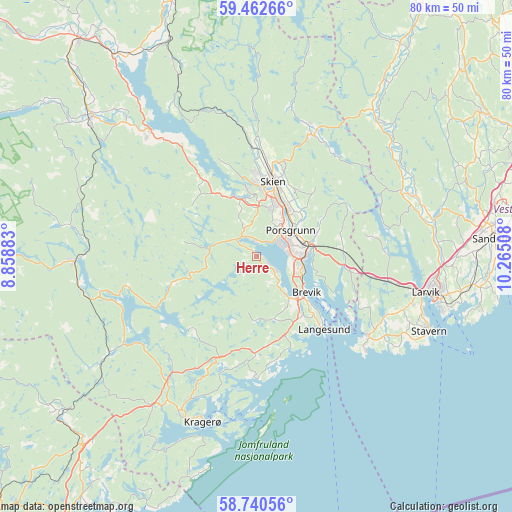
Herre GPS coordinates[2]
59° 6' 12.636" North, 9° 33' 43.02" East
| Map corner | latitude | longitude |
|---|---|---|
| Upper-left | 59.46266°, | 8.85883° |
| Center: | 59.10351°, | 9.56195° |
| Lower-right: | 58.74056°, | 10.26508° |
| Map W x H: | 80.3×80.3 km | = 49.9×49.9mi |
| max Lat: | 71.04137° ⇑88.4% North |
| Herre: | 59.10351° |
| min Lat: | ⇓11.6% South 58.0274° |
| min Long | Herre | max Long |
| 4.71485° | 9.56195° | 31.11066° |
| W 44.3%⇐ | ⇒55.7% E |
Elevation
Elevation of Herre is 12 m = 39 ft, and this is 92.2 m = 302 ft below average elevation for this country.
| Max E: |
897 m = 2943 ft | 77.8% |
| Avg. | 104.2 m = 342 ft | |
| Herre | 12 m = 39 ft | |
Min E: |
1 m = 3 ft | 22.2% |
See also: Norway elevation on elevation.city.
Geographical zone
Herre is located in North temperate zone (between Tropic of Cancer and the Arctic Circle). Distance of this North polar circle is 829.5 km =515.4 mi to North.| Distance of | km | miles | from Herre |
|---|---|---|---|
| North Pole | 3435.4 | 2134.7 | to North |
| Arctic Circle | 829.5 | 515.4 | to North |
| Tropic Cancer | 3965.8 | 2464.2 | to South |
| Equator | 6571.7 | 4083.5 | to South |


Nearby cities:
15 places around Herre: (largest is in red/bold)
• Gvarv
38.6 km =24 mi,  324°
324°
• Kil
27.9 km =17.3 mi,  212°
212°
• Kragerø
27.4 km =17 mi,  197°
197°
• Kvelde
25.2 km =15.7 mi,  66°
66°
• Langangen
14 km =8.7 mi,  97°
97°
• Langesund
15.6 km =9.7 mi,  136°
136°
• Larvik
27.6 km =17.1 mi, 101°
• Lunde
34 km =21.1 mi,  309°
309°
• Porsgrunn
6.8 km =4.2 mi,  52°
52°
• Prestestranda
28.7 km =17.8 mi,  268°
268°
• Sandefjord
37.5 km =23.3 mi,  85°
85°
• Siljan
22.2 km =13.8 mi,  22°
22°
• Skien
12.1 km =7.5 mi,  12°
12°
• Stavern
29.3 km =18.2 mi,  113°
113°
• Ulefoss
26.1 km =16.2 mi, 319°
Sources, notices
• [Note1] Compared only with cities in Norway existing in our database
• [Src1] Map data: © OpenStreetMap contributors (CC-BY-SA)
• [Src2] Other city data from geonames.org with taken over terms of usage.
• [Src3] Geographical zone / Annual Mean Temperature by Robert A. Rohde @ Wikipedia
