Fillan geodata
Fillan (Trøndelag) is a seat of a second-order administrative division; located in Norway in Europe/Oslo (GMT+2) time zone. With population of 510 people, there are 458 cities with bigger population in this country. Compared to other cities in Norway, 78% of cities are located further ↓South; 60.1% of cities are located further →East and 69% of cities have higher elevation than Fillan. Note1


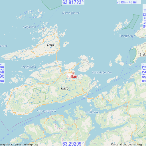
Fillan GPS coordinates[2]
63° 36' 22.968" North, 8° 58' 10.596" East
| Map corner | latitude | longitude |
|---|---|---|
| Upper-left | 63.91723°, | 8.26648° |
| Center: | 63.60638°, | 8.96961° |
| Lower-right: | 63.29209°, | 9.67273° |
| Map W x H: | 69.5×69.5 km | = 43.2×43.2mi |
| max Lat: | 71.04137° ⇑22% North |
| Fillan: | 63.60638° |
| min Lat: | ⇓78% South 58.0274° |
| min Long | Fillan | max Long |
| 4.71485° | 8.96961° | 31.11066° |
| W 39.9%⇐ | ⇒60.1% E |
Elevation
Elevation of Fillan is 20 m = 66 ft, and this is 84.2 m = 276 ft below average elevation for this country.
| Max E: |
897 m = 2943 ft | 69% |
| Avg. | 104.2 m = 342 ft | |
| Fillan | 20 m = 66 ft | |
Min E: |
1 m = 3 ft | 31% |
See also: Norway elevation on elevation.city.
Geographical zone
Fillan is located in North temperate zone (between Tropic of Cancer and the Arctic Circle). Distance of this North polar circle is 328.8 km =204.3 mi to North.| Distance of | km | miles | from Fillan |
|---|---|---|---|
| North Pole | 2934.7 | 1823.5 | to North |
| Arctic Circle | 328.8 | 204.3 | to North |
| Tropic Cancer | 4466.4 | 2775.3 | to South |
| Equator | 7072.4 | 4394.6 | to South |


Nearby cities:
15 places around Fillan: (largest is in red/bold)
• Aure
43.5 km =27 mi,  210°
210°
• Botngård
45 km =28 mi,  66°
66°
• Brekstad
35.5 km =22.1 mi,  75°
75°
• Børsa
62.8 km =39 mi,  119°
119°
• Hopen
49.9 km =31 mi,  251°
251°
• Krokstadøra
34.9 km =21.7 mi,  130°
130°
• Kyrksæterøra
35.6 km =22.1 mi,  170°
170°
• Lensvik
42.7 km =26.5 mi,  103°
103°
• Liabøen
62.9 km =39.1 mi, 211°
• Løkken Verk
64.8 km =40.3 mi,  145°
145°
• Orkanger
55 km =34.2 mi, 127°
• Rindal
62.4 km =38.8 mi, 168°
• Rissa
49 km =30.4 mi,  92°
92°
• Sistranda
14.8 km =9.2 mi,  333°
333°
• Skaun
66.8 km =41.5 mi, 126°
Sources, notices
• [Note1] Compared only with cities in Norway existing in our database
• [Src1] Map data: © OpenStreetMap contributors (CC-BY-SA)
• [Src2] Other city data from geonames.org with taken over terms of usage.
• [Src3] Geographical zone / Annual Mean Temperature by Robert A. Rohde @ Wikipedia
