Fossby geodata
Fossby (Østfold) is a seat of a second-order administrative division; located in Norway in Europe/Oslo (GMT+2) time zone. With population of 318 people, there are 480 cities with bigger population in this country. Compared to other cities in Norway, 86.1% of cities are located further ↑North; 79.4% of cities are located further ←West and 69% of cities have lower elevation than Fossby. Note1


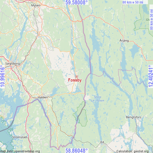
Fossby GPS coordinates[2]
59° 13' 19.848" North, 11° 41' 57.408" East
| Map corner | latitude | longitude |
|---|---|---|
| Upper-left | 59.58008°, | 10.99616° |
| Center: | 59.22218°, | 11.69928° |
| Lower-right: | 58.86048°, | 12.40241° |
| Map W x H: | 80×80 km | = 49.7×49.7mi |
| max Lat: | 71.04137° ⇑86.1% North |
| Fossby: | 59.22218° |
| min Lat: | ⇓13.9% South 58.0274° |
| min Long | Fossby | max Long |
| 4.71485° | 11.69928° | 31.11066° |
| W 79.4%⇐ | ⇒20.6% E |
Elevation
Elevation of Fossby is 119 m = 390 ft, and this is 14.8 m = 49 ft above average elevation for this country.
| Max E: |
897 m = 2943 ft | 31% |
| Fossby | 119 m 390 ft | |
| Avg. | 104.2 m = 342 ft | |
Min E: |
1 m = 3 ft | 69% |
See also: Norway elevation on elevation.city.
Geographical zone
Fossby is located in North temperate zone (between Tropic of Cancer and the Arctic Circle). Distance of this North polar circle is 816.3 km =507.2 mi to North.| Distance of | km | miles | from Fossby |
|---|---|---|---|
| North Pole | 3422.2 | 2126.5 | to North |
| Arctic Circle | 816.3 | 507.2 | to North |
| Tropic Cancer | 3979 | 2472.4 | to South |
| Equator | 6584.9 | 4091.7 | to South |


Nearby cities:
15 places around Fossby: (largest is in red/bold)
• Askim
50.3 km =31.3 mi,  322°
322°
• Fredrikstad
43.8 km =27.2 mi,  269°
269°
• Halden
20.8 km =12.9 mi,  238°
238°
• Ise
28.6 km =17.8 mi,  287°
287°
• Karlshus
49.1 km =30.5 mi, 287°
• Lervik
54.5 km =33.9 mi,  275°
275°
• Meieribyen
41.5 km =25.8 mi,  312°
312°
• Mysen
42.5 km =26.4 mi,  330°
330°
• Rakkestad
30.2 km =18.8 mi, 318°
• Sarpsborg
34.2 km =21.3 mi, 281°
• Skjeberg
29 km =18 mi, 267°
• Skjærhalden
43.7 km =27.2 mi, 239°
• Skjønhaug
51.3 km =31.9 mi,  335°
335°
• Slevik
49.9 km =31 mi, 266°
• Ørje
28.8 km =17.9 mi,  355°
355°
Sources, notices
• [Note1] Compared only with cities in Norway existing in our database
• [Src1] Map data: © OpenStreetMap contributors (CC-BY-SA)
• [Src2] Other city data from geonames.org with taken over terms of usage.
• [Src3] Geographical zone / Annual Mean Temperature by Robert A. Rohde @ Wikipedia
