Halden geodata
Halden (Østfold) is a seat of a second-order administrative division; located in Norway in Europe/Oslo (GMT+2) time zone. With population of 21,970 people, there are 23 cities with bigger population in this country. Compared to other cities in Norway, 88.1% of cities are located further ↑North; 76.4% of cities are located further ←West and 73.9% of cities have higher elevation than Halden. Note1


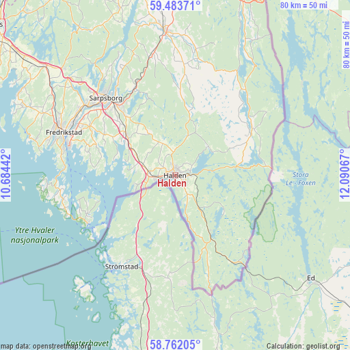
Halden GPS coordinates[2]
59° 7' 29.208" North, 11° 23' 15.144" East
| Map corner | latitude | longitude |
|---|---|---|
| Upper-left | 59.48371°, | 10.68442° |
| Center: | 59.12478°, | 11.38754° |
| Lower-right: | 58.76205°, | 12.09067° |
| Map W x H: | 80.2×80.2 km | = 49.8×49.8mi |
| max Lat: | 71.04137° ⇑88.1% North |
| Halden: | 59.12478° |
| min Lat: | ⇓11.9% South 58.0274° |
| min Long | Halden | max Long |
| 4.71485° | 11.38754° | 31.11066° |
| W 76.4%⇐ | ⇒23.6% E |
Elevation
Elevation of Halden is 15 m = 49 ft, and this is 89.2 m = 293 ft below average elevation for this country.
| Max E: |
897 m = 2943 ft | 73.9% |
| Avg. | 104.2 m = 342 ft | |
| Halden | 15 m = 49 ft | |
Min E: |
1 m = 3 ft | 26.1% |
See also: Norway elevation on elevation.city.
Geographical zone
Halden is located in North temperate zone (between Tropic of Cancer and the Arctic Circle). Distance of this North polar circle is 827.1 km =513.9 mi to North.| Distance of | km | miles | from Halden |
|---|---|---|---|
| North Pole | 3433 | 2133.2 | to North |
| Arctic Circle | 827.1 | 513.9 | to North |
| Tropic Cancer | 3968.1 | 2465.7 | to South |
| Equator | 6574.1 | 4085 | to South |


Nearby cities:
15 places around Halden: (largest is in red/bold)
• Fossby
20.8 km =12.9 mi,  58°
58°
• Fredrikstad
28.1 km =17.5 mi,  291°
291°
• Ise
21.7 km =13.5 mi,  334°
334°
• Karlshus
38.7 km =24 mi,  310°
310°
• Larkollen
47 km =29.2 mi,  299°
299°
• Lervik
40 km =24.9 mi, 294°
• Meieribyen
41 km =25.5 mi,  341°
341°
• Rakkestad
33.5 km =20.8 mi,  355°
355°
• Rygge
45.9 km =28.5 mi, 307°
• Ryggebyen
45.7 km =28.4 mi, 307°
• Sarpsborg
23.7 km =14.7 mi,  318°
318°
• Skjeberg
14.8 km =9.2 mi, 310°
• Skjærhalden
22.9 km =14.2 mi,  241°
241°
• Slevik
33 km =20.5 mi,  283°
283°
• Ørje
42.4 km =26.3 mi,  21°
21°
Sources, notices
• [Note1] Compared only with cities in Norway existing in our database
• [Src1] Map data: © OpenStreetMap contributors (CC-BY-SA)
• [Src2] Other city data from geonames.org with taken over terms of usage.
• [Src3] Geographical zone / Annual Mean Temperature by Robert A. Rohde @ Wikipedia
